.
🔥 Get CES, CBT Test Answers in PDF!
Site categories
1/ Help
:

SETS 6000 (Seafarer Evaluation Training System) Test Online for Seamen on DO1B – Plan and Conduct a Passage – Terrestrial and Coastal Navigation

Join Our Telegram (Seaman Community)

Welcome to the website where you can pass online the Seafarer Evaluation Training System (SETS) test on «DO1B – Plan and Conduct a Passage – Terrestrial and Coastal Navigation». Practice like this will help you as a marine specialist improve your knowledge with the help of online studying and appraisal practice. SETS based on practical information and marine specialists experience.

SETS tests developed for evaluating seaman basic knowledge by company “Naval Education Services” is an evaluating online-tool, used for revealing any professional preparation needed in specific fields of knowledge, defined by STCW Section A-V/1-2.

SETS tests have proven themselves as good tools for the selection and recruitment process, as well as advancing the level of knowledge of the current officers and crew.

Current test contains SETS questions in area «DO1B – Plan and Conduct a Passage – Terrestrial and Coastal Navigation». Those questions can be used for competence verification specialist capable of preventing accidental situations related with transporting safety, or also for self-examination.

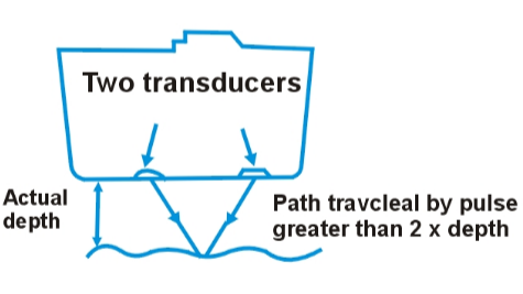
«DO1B – Plan and Conduct a Passage – Terrestrial and Coastal Navigation» subject includes theoretical and practical information about advanced training for work on any type of vessel. The examination rigorously tests a candidate’s ability to create a comprehensive and safe passage plan from berth to berth. A significant part of the practical assessment involves demonstrating proficiency in traditional navigation techniques using paper charts. Candidates must accurately calculate tidal heights and stream data to determine under-keel clearance and optimize a vessel’s track. The test evaluates the skill of fixing a ship’s position using terrestrial objects, such as bearings, transits and horizontal sextant angles. Participants are required to identify and effectively use all standard chart symbols, abbreviations and critical navigational marks. A key component involves assessing the ability to manage navigation in restricted visibility or during equipment failure. The theoretical test covers the application of the International Regulations for Preventing Collisions at Sea (COLREGs) within coastal traffic situations. Successful completion certifies the necessary competence to plan and execute a coastal voyage, ensuring the safety of the vessel and its crew.

On this site SETS on the subject «DO1B – Plan and Conduct a Passage – Terrestrial and Coastal Navigation» contains 46 questions you need to answer with no possibility to go back to previous question. Therefore, we recommend carefully reading each question and making decision with no hurry. In case you have some difficulty answering, you have also possibility to request a hint.

Choose the regime, in which you want to pass SETS test:

Start test
* Some questions may have more than 1 correct answer.

“SETS test” finished! Your result:
Correct answers:

Use the search below to find question.

Amount of questions: 46.

Right answers marked with this sign .

You are on watch at night and you stop the main engines. What changes would you make to your navigational lights?
Switch the steaming lights off.
Switch on three vertical red lights.
Switch on two vertical red lights and switch off all other navigational lights.
Switch on two vertical red lights and switch off steaming lights.
You see a two flag signal on a ship close-by. What publication would you consult to discover its meaning?
Admiralty List of Radio Signals.
Mariner’s Handbook.
International Code of Signals.
Nautical Almanac.
Why should the largest scale chart available be used for navigational purposes?
Because it uses larger symbols.
Because it uses better colour.
Because it shows more accurate information.
Because the brightest lights are shown.
Which is the more accurate means of position fixing?
A radar range and bearing.
Two radar bearings.
Two visual bearings.
A visual bearing and a radar range.
You expect to sight land at 2100. By 2120 no land has been sighted, the visibility is good. What action would you take?
Keep looking out.
Call the master.
Stop engines.
Alter course.
A vessel is under pilotage approaching a European port. Who is responsible for the safe navigation of the vessel?
The pilot.
The master and duty officers.
The traffic controller.
The pilot and the master together.
Where would you find information about a vessel reporting system for a port which you are about to enter?
Mariner’s Handbook.
International Code of Signals.
Admiralty List of Radio Signals.
Ocean Passages for the World.
Your vessel is carrying a full cargo of scrap steel. Which item of bridge equipment is likely to be unreliable?
The satellite navigator.
The echo sounder.
The gyro compass.
The magnetic compass.
What time is used for the ship’s course recorder?
Local time.
Ship’s time.
GMT.
Company head office time.
Which of the following options would be considered “good seamanship“?
Using radar when proceeding at full speed in fog.
Sounding a fog signal when in clear weather, but approaching a fog bank.
Using deck and accommodation lights to indicate the presence of your ship in poor visibility.
Proceeding on the port side of a narrow channel to take advantage of a favourable current.
When must a passage plan be prepared?
Gradually during a sea voyage.
Before the voyage commences.
Whenever requested by a pilot.
Any of the other options.
What should a passage plan include?
The plan should include the first 72 hours of the sea voyage.
The plan should include the entire voyage from berth to berth.
The plan should cover the first half of the sea voyage.
The OOW decides what to include in the passage plan.
In which publication can information on ship reporting be found?
ALRS.
Ship Routeing.
IAMSAR.
SOPEP Manual.
The vertical distance between the sea bed and the deepest part of the keel is known as the:
Underkeel clearance.
Draft.
Depth.
Sounding.
What is a routeing measure aimed at the separation of opposing streams of traffic by establishing traffic lanes called?
Traffic separation scheme.
Traffic Lane.
Separation Zone.
Sounding.
How often are chart corrections published?
Weekly.
Monthly.
Yearly.
Annually.
What is the vertical distance on a given day between the water surface at high and low water called?
Range of tides.
Height of tide.
Highest astronomical tide.
Lowest astronomical tide.
The best position fix is obtained when the bearings of two objects are:
90 degrees apart.
45 degrees apart.
180 degrees apart.
135 degrees apart.
What are sailing directions also known as?
Pilot books.
Guide to port entry.
Routeing charts.
Passage planning charts.
When selecting the maximum distance at which a landfall light would be visible, which of the following should be selected?
Lesser of the two (geographical & nominal range).
Geographical range.
Nominal range.
Greater of the two (geographical & nominal range).
Where is the title of the navigation chart printed?
In some convenient, conspicuous place, where it does not hinder navigation or the use of it.
Always at the center of the chart.
Where the sea areas are located.
Always at the bottom left hand margin.
What does this figure indicate on a navigation chart?

West cardinal buoy

West cardinal buoy.
East cardinal buoy.
North cardinal buoy.
South cardinal buoy.
On a navigational chart, what does this figure indicate?

Sign: windmill

Windmill.
Wind-motor.
Chimney.
Pillar.
What is the east – west distance between two points called?
Departure.
D’long.
D’lat.
DMP.
When using great circle sailing the saving in distance is the most when:
The course is E-W, nearer to the poles.
At the equator.
The course is N-S.
The course is one of the inter-cardinal headings.
On a navigational chart, how is the probable direction of the predominant direction of sea surface current indicated?

Predominant direction

Letter a.
Letter b.
Letter c.
Letter d.
On which side of this buoy should you pass?

Scheme on the radar

South.
North.
East.
West.
Under soundings marked on the chart, the nature of the sea bottom is also indicated. What does Sh indicate?
Shells.
Corals.
Soft mud.
Shingle.
What charts are used for coasting, pilotage waters and plotting waypoints?
Large scale.
Small scale.
Routeing.
Instructional.
In which publication can information on VTS be found?
ALRS.
Tide Tables.
Routeing Charts.
Chart Catalogues.
Where can you find the symbols and abbreviations used on the Admiralty charts?
Chart 5011.
Chart 5022.
Chart catalogue.
Notices to mariners.
Who publishes the chart catalogue?
Hydrographer to the Navy.
IMO.
ICS.
HMSO.
A navigational position line is a part of a:
Position circle.
Small circle.
Segment.
All of the other options.
On a navigational chart, what does this figure indicate?

Navigational Chart

Sector lights.
Heading lights.
Direction lights.
All of the other options.
What is the line roughly following the 180th meridian called?
The date line.
The Greenwich meridian.
The Equator.
A rhumb line.
What is the meaning of the symbol Cl on a navigational chart?
Clay.
Coral.
Cloud.
Cill.
Where will you find a comprehensive list of navigation charts with the title and number for various parts of the world?
Chart catalogue.
Chart 5011.
Chart folio.
Sailing directions.
The direction towards which a tidal stream runs is called:
Set.
Drift.
Current.
Leeway.
In what direction does the axis of the gyro-compass wheel point?
True North.
Magnetic North.
North Relative.
Compass North.
How often is a chart catalogue published?
Annually.
Monthly.
Twice a year.
Weekly.
The correct order to follow when planning a passage is:
Appraise, plan, monitor, execute.
Plan, appraise, monitor, execute.
Plan, monitor, appraise, execute.
Plan, monitor, execute, appraise.
What charts are used for plotting Great Circle courses?
Gnomonic.
Instructional.
Routeing.
Passage planning.
Which error in the echo sounder is illustrated in the diagram?

Echo sounder

Pythagoras.
Multiple error.
Velocity error.
False bottom echoes.
Distance on a chart is measured using:
Latitude scale.
Longitude scale.
Any uniform scale.
None of the given options.
The relationship between the distance on the earth and the length by which that distance is shown on the navigation chart is called the:
Natural scale.
Actual scale.
Calculated scale.
Variable scale.
What does this chart symbol mean?

Symbol - direction of buoyage

Direction of Buoyage.
Direction of Tidal Stream.
Direction of Traffic Lane.
Direction of Prevailing Wind.

Did you find mistake? Highlight and press CTRL+Enter

Сентябрь, 06, 2025 90 0
5/5 - (2 голоса)
SOC.MEDIA Telegram Vkontakte Facebook Odnoklassniki Instagram
Add a comment