In the vast and unpredictable expanse of the world’s oceans, ensuring the safety of vessels and their crews is paramount. Inmarsat SafetyNET stands as a cornerstone in maritime safety, providing critical information to ships at sea. This article delves into the intricacies of the SafetyNET service, offering a comprehensive overview of its features, operations, and the vital role it plays in the dissemination of Maritime Safety Information (MSI).
- Preface
- General Information
- SafetyNET Service
- Introduction
- Definitions
- General Features of the EGC System
- Planning of New SafetyNET Services
- Authorization, Certification and Registration of SafetyNET information
providers - International SafetyNET Co-ordinating Panel
- Changes to Existing SafetyNET Services
- Operation of the International SafetyNET Service
- Operational Guidance
- Promulgation of Maritime Safety Information
- The Inmarsat system
Whether you’re a seasoned mariner or new to the maritime industry, this guide will equip you with the knowledge to understand and utilize Inmarsat SafetyNET effectively.
Preface
SOLAS regulation IV/12.2 states that “Every ship, while at sea, shall maintain a radio watch for broadcasts of maritime safety information on the appropriate frequency or frequencies on which such information is broadcast for the area in which the ship is navigating“.
At the request of the IMO Sub-Committee on Radiocommunications, the International SafetyNET Manual was first produced in 1994. The second edition was published in 2003 containing amendments endorsed by the Maritime Safety Committee at its seventy-sixth session in December 2002 by MSC/Circ.1064.
At its seventh meeting in September 2005, the IHO‘s Commission on the Promulgation of Radio Navigational Warnings (CPRNW CPRNW was renamed the IHO WWNWS Sub Committee (WWNWS) with effect from 1 January 2009.x) established a Working Group to review all World-Wide Navigational Warning Service (WWNWS) documentation. The Working Group included representation from the WMO and prepared at first, revisions to IMO resolutions A.705(17), “Promulgation of Maritime Safety Information” and A.706(17), “World-Wide Navigational Warning Service“. The proposed revisions of the resolutions were circulated to IHO Member States under IHB CL 104/2007, endorsed by COMSAR at its twelfth session in April 2008 and subsequently approved by the Maritime Safety Committee at its eighty-fifth session in November/December 2008 by MSC.1/Circ.1287 and MSC.1/Circ.1288 respectively.
The IHO CPRNW Working Group then prepared the revised Joint IMO/IHO/WMO Manual on Maritime Safety Information incorporating the revised information from resolutions A.705(17), as amended and A.706(17), as amended. The revised text of the Joint IMO/IHO/WMO Manual on Maritime Safety Information was circulated to IHO Member States under cover of IHB CL 70/2008, endorsed by COMSAR at its thirteenth session in January 2009 and subsequently approved by the Maritime Safety Committee at its eighty-sixth session in May/June 2009 by MSC.1/Circ.1310.
Continuing with the holistic approach of reviewing all the MSI documents from the top-down, the IHO WWNWS Working Group prepared the third revision of the International SafetyNET Manual. The revised text of the International SafetyNET Manual was circulated to IHO Member States under cover of IHB CL 68/2009, endorsed by COMSAR at its fourteenth session in March 2010 and subsequently approved by the Maritime Safety Committee at its eighty-seventh session in May 2010.
General Information
SafetyNET is an international automatic direct-printing satellite-based service for the promulgation of navigational and meteorological warnings, meteorological forecasts, Search and Rescue (SAR) information and other urgent safety-related messages – maritime safety information (MSI) – to ships.
It has been developed as a safety service of the Inmarsat-C enhanced group call system to provide a simple and automated means of receiving MSI on board ships at sea. The message-selection features of SafetyNET receivers enable mariners to receive safety information broadcasts that are tailored to their particular needs.
SafetyNET Service
Introduction
SafetyNET provides shipping with navigational and meteorological warnings, meteorological forecasts, shore-to-ship distress alerts, SAR information and other urgent information in accordance with the requirements of the International Convention for the Safety of Life at Sea (SOLAS), 1974, as amended. It is suitable for use in all sizes and types of ships. Figure 1 illustrates the way the service is structured.

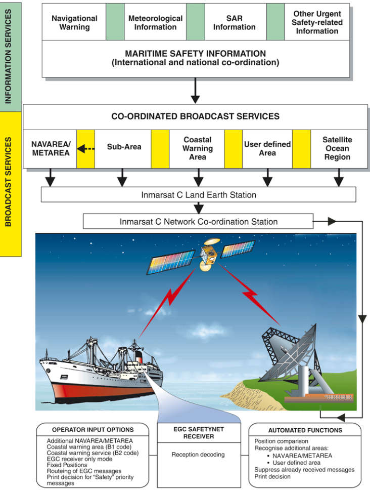
SafetyNET is a service of Inmarsat’s Enhanced Group Call (EGC) system and was specifically designed for promulgation of MSI as a part of the GMDSS. The EGC system (technically a part of the Inmarsat-C system) provides an automatic method of broadcasting messages to both fixed and variable geographical areas. It is designed with the capability to provide services within the coverage areas of geostationary satellites, know as satellite ocean regions (approximately between 76° N and 76° S). In addition to providing services to ships operating in sea area A3, it also provides the means of disseminating MSI to coastal warning areas not covered by the International NAVTEX service.
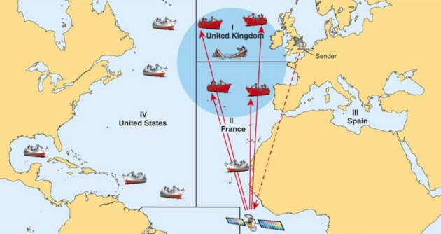
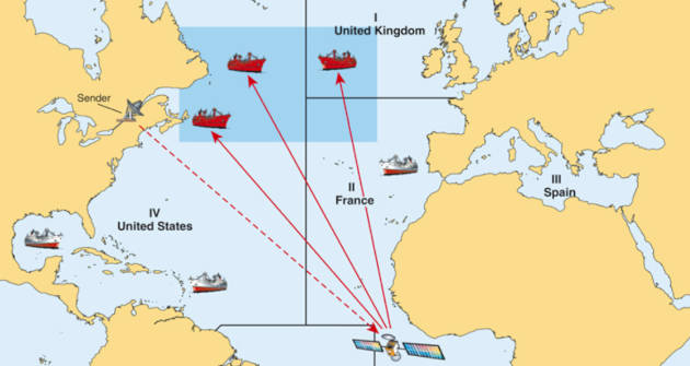
SafetyNET offers the ability to direct a message to a given geographical area. The area may be fixed, as in the case of a NAVAREA/METAREA or coastal warning area; or it may be a user defined area (circular or rectangular). A user defined area is used for messages, such as a local storm warning or a shore-to-ship distress alert, for which it is inappropriate to alert ships in an entire satellite ocean region or NAVAREA/METAREA. The general EGC system capabilities are shown in Figure 2.

SafetyNET messages are submitted by registered information providers for broadcast to the appropriate satellite ocean region(s) via an Inmarsat-C Land Earth Station (LES). Messages are broadcast according to their priority, i. e. distress, urgency or safety. Aboard ship, messages are received by type-approved Inmarsat-C or Mini-C mobile terminals with EGC SafetyNET capability.
Definitions
For the purposes of this manual, the following definitions apply:
1 Coastal warning means a navigational warning promulgated as part of a numbered series by a National co-ordinator. Broadcast shall be made by the International NAVTEX service to defined NAVTEX service areas and/or by the International SafetyNET service to coastal warning areas. (In addition, Administrations may issue coastal warnings by other means.)
2 Coastal warning area means a unique and precisely defined sea area within a NAVAREA/METAREA or Sub-Area established by a coastal state for the purpose of co-ordinating the broadcast of coastal maritime safety information through the SafetyNET service.
3 Enhanced Group Call (EGC) means the system for broadcasting messages via the mobile satellite communications system operated by Inmarsat Global Limited. EGC is a part of the Inmarsat-C system and supports two services: SafetyNET and FleetNET.
4 FleetNET means the commercial service for the broadcasting and automatic reception of fleet management and general public information by means of direct printing through Inmarsat’s EGC system. Some receivers for FleetNET may not be able to receive SafetyNET.
5 Global Maritime Distress and Safety System (GMDSS) means the global communications service based upon automated systems, both satellite and terrestrial, to provide distress alerting and promulgation of Maritime Safety Information for mariners.
6 HF NBDP means High Frequency narrow-band direct-printing, using radio telegraphy as defined in Recommendation ITU-R M.688.
7 In-force bulletin means a list of serial numbers of those NAVAREA, Sub-Area or coastal warnings in force issued and broadcast by the NAVAREA co-ordinator, Sub-Area co-ordinator or National co-ordinator during at least the previous six weeks.
8 Inmarsat B means the digital satellite communications system for transmission of voice, telex, facsimile or data using directional antennas. Note: Inmarsat B will be discontinued from 31 December 2014.
9 Inmarsat-C means the digital satellite communications system for store-and-forward text or data messaging using mobile terminals with omni-directional antennas. Inmarsat-C is the only system that allows ships to meet the majority of the satellite communication requirements of the GMDSS including distress alerting, reception of maritime safety information and general communications.
10 Inmarsat Mini-C means smaller terminals, based on the same technical requirements as Inmarsat-C terminals. Some models are approved as GMDSS compliant terminals.
11 Inmarsat Fleet means the digital satellite communication system that provides voice and flexible data communication services, e-mail and secure internet access for maritime users, comprising a family of Fleet F77, F55 and F33 mobile terminals. The Inmarsat Fleet F77 system provides voice distress and safety functionality and meets the requirements of IMO resolution A.1001(25).
12 Inmarsat FleetBroadband means the communication service that provides voice and high-speed data services, simultaneously, through compact terminals for maritime users.
13 International NAVTEX service means the co-ordinated broadcast and automatic reception on 518 kHz of maritime safety information by means of narrow-band direct-printing telegraphy using the English language As set out in the IMO NAVTEX Manual.x.
14 International SafetyNET service means the co-ordinated broadcasting and automated reception of maritime safety information via the Inmarsat Enhanced Group Call (EGC) system, using the English language, in accordance with the provisions of the International Convention for the Safety of Life at Sea, 1974, as amended.
15 Land Earth Station (LES) means a fixed terrestrial station acting as a gateway between terrestrial communication networks and the Empowering Global Communication with INMARSAT Satellites in shippingInmarsat satellites in the maritime mobile-satellite service. This may also be referred to as a Coast Earth Station (CES).
16 Land Earth Station Operator (LESO) means an Inmarsat service provider which owns and operates the LES.
17 Local warning means a navigational warning which covers inshore waters, often within the limits of jurisdiction of a harbour or port authority.
18 Maritime safety information (MSI) As defined in Regulation IV/2 of the 1974 SOLAS Convention, as amended.x means navigational and meteorological warnings, meteorological forecasts and other urgent safety-related messages broadcast to ships.
19 Maritime safety information service means the internationally and nationally co-ordinated network of broadcasts containing information which is necessary for safe navigation.
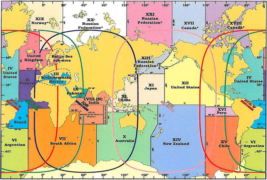
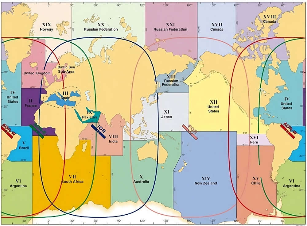
20 METAREA means a geographical sea area Which may include inland seas, lakes and waterways navigable by sea-going ships.x established for the purpose of co-ordinating the broadcast of marine meteorological information. The term METAREA followed by a roman numeral may be used to identify a particular sea area. The delimitation of such areas is not related to and shall not prejudice the delimitation of any boundaries between States (See Figure 3).

21 METAREA issuing service means the National Meteorological Service which has accepted responsibility for ensuring that meteorological forecasts and warnings are disseminated through the Inmarsat SafetyNET service to the designated METAREA or other area.
22 Meteorological information means the marine meteorological warning and forecast information in accordance with the provisions of the International Convention for the Safety of Life at Sea, 1974, as amended.
23 Mobile Earth Station (MES) means a mobile user terminal in the Inmarsat maritime mobile-satellite service. This may also be referred to as Ship Earth Station (SES).
24 National co-ordinator means the national authority charged with collating and issuing coastal warnings within a national area of responsibility.
25 National NAVTEX service means the broadcast and automatic reception of maritime safety information by means of narrow-band direct-printing telegraphy using frequencies other than 518 kHz and languages as decided by the Administration concerned.
26 National SafetyNET service means the broadcasting and automated reception of maritime safety information via the Inmarsat EGC system, using languages as decided by the Administration concerned.
27 NAVAREA means a geographical sea area established for the purpose of co-ordinating the broadcast of navigational warnings. The term NAVAREA followed by a roman numeral may be used to identify a particular sea area. The delimitation of such areas is not related to and shall not prejudice the delimitation of any boundaries between States (See Figure 4).

28 NAVAREA co-ordinator means the authority charged with co-ordinating, collating and issuing NAVAREA warnings for a designated NAVAREA.
29 NAVAREA warning means a navigational warning or in-force bulletin promulgated as part of a numbered series by a NAVAREA co-ordinator.
30 Navigational warning means a message containing urgent information relevant to safe navigation broadcast to ships in accordance with the provisions of the International Convention for the Safety of Life at Sea, 1974, as amended.
31 NAVTEX means the system for the broadcast and automatic reception of maritime safety information by means of narrow-band direct-printing telegraphy.
32 NAVTEX service area means a unique and precisely defined sea area for which maritime safety information is provided from a particular NAVTEX transmitter.
33 NAVTEX co-ordinator means the authority charged with operating and managing one or more NAVTEX stations broadcasting maritime safety information as part of the International NAVTEX service.
34 Network Co-ordination Station (NCS) means a fixed land station in the Inmarsat satellite communications system which controls channel assignments and provides the network management functions for each of the four satellite ocean regions. NCSs also transmit EGC messages on the NCS common channel.
35 Other urgent safety-related information means maritime safety information broadcast to ships that is not defined as a navigational warning, meteorological information or SAR information. This may include, but is not limited to, significant malfunctions or changes to maritime communications systems, and new or amended mandatory ship reporting systems or maritime regulations affecting ships at sea.
36 Registered information provider means a maritime safety information provider (MSI provider), authorized in accordance with Annex 2 of the International SafetyNET Manual, which has an agreement with one or more LES(s) for providing SafetyNET services.
37 Rescue Co-ordination Centre (RCC) means a unit responsible for promoting efficient organization of search and rescue services and for coordinating the conduct of search and rescue operations within a search and rescue region.
38 SafetyNET means the international service for the broadcasting and automatic reception of maritime safety information via the Inmarsat EGC system. SafetyNET receiving capability is part of the mandatory equipment which is required to be carried by certain ships in accordance with the provisions of the International Convention for the Safety of Life at Sea, 1974, as amended.
39 SAR information means distress alert relays and other urgent search and rescue information broadcast to ships.
40 Satellite Ocean Region means the area on the earth’s surface within which a mobile or fixed antenna can obtain line-of-sight communications with one of the four primary Inmarsat geostationary satellites. This area may also be referred to as the “footprint“:
- Atlantic Ocean Region – East (AOR-E);
- Atlantic Ocean Region – West (AOR-W);
- Indian Ocean Region (IOR);
- Pacific Ocean Region (POR).
41 Sea Area A1 means an area within the radiotelephone coverage of at least one VHF coast station in which continuous DSC Digital selective calling (DSC) means a technique using digital codes which enables a radio station to establish contact with and transfer information to another station or group of stations and complying with the relevant recommendations of the International Radio Consultative Committee ((CCIR) – “Radiocommunications Bureau of the International Telecommunication Union (ITU)” from 1 March 1993).x alerting is available, as may be defined by a Contracting Government.
42 Sea Area A2 means an area, excluding sea area A1, within the radiotelephone coverage of at least one MF coast station in which continuous DSC alerting is available, as may be defined by a Contracting Government.
43 Sea Area A3 means an area, excluding sea areas A1 and A2, within the coverage of an Inmarsat geostationary satellite in which continuous alerting is available.
44 Sea Area A4 means an area outside sea areas A1, A2 and A3.
45 Sub-Area means a sub-division of a NAVAREA/METAREA in which a number of countries have established a co-ordinated system for the promulgation of maritime safety information. The delimitation of such areas is not related to and shall not prejudice the delimitation of any boundaries between States.
46 Sub-Area co-ordinator means the authority charged with co-ordinating, collating and issuing Sub-Area warnings for a designated Sub-Area.
47 Sub-Area warning means a navigational warning promulgated as part of a numbered series by a Sub-Area co-ordinator. Broadcast shall be made by the International NAVTEX service to defined NAVTEX service areas or by the International SafetyNET service (through the appropriate NAVAREA co-ordinator).
48 User defined area means a temporary geographic area, either circular or rectangular, to which maritime safety information is addressed.
49 UTC means Co-ordinated Universal Time which is equivalent to GMT (or ZULU) as the international time standard.
50 World-Wide Navigational Warning Service (WWNWS) As set out in resolution A.706(17), as amended.x means the internationally and nationally co-ordinated service for the promulgation of navigational warnings.
51 In the operating procedures co-ordination means that the allocation of the time for data broadcast is centralized, the format and criteria of data transmissions are compliant as described in the Joint IMO/IHO/WMO Manual on Maritime Safety Information and that all services are managed as set out in IMO resolutions A.705(17), as amended and A.706(17), as amended.
General Features of the EGC System
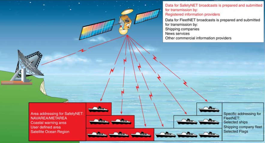
The Inmarsat-C EGC system supports two different services:
- SafetyNET – for promulgation of MSI, and;
- FleetNET – for transmission of fleet management, general public information and other information to fleets or groups of ships. The FleetNET service is not part of the GMDSS.
All navigable waters of the world between 76° N and 76° S are covered by satellites in the Inmarsat system. Each satellite transmits EGC messages on a designated channel; this channel is optimized to enable the signal to be received by Inmarsat-C or Mini-C terminals with EGC SafetyNET capability. Reception of EGC messages is normally not affected by the position of the ship within the satellite ocean region, atmospheric conditions or time of day.
SafetyNET messages are addressed to a geographical area (area calls), where as FleetNET messages are addressed to groups of ships (group calls):
- Area calls (SafetyNET) can be addressed to a fixed geographical area (NAVAREA/METAREA or coastal warning area) or to a user defined area selected by an MSI provider. Area calls will be received automatically by any SafetyNET receiver within the area. To receive SafetyNET coastal warnings, the EGC receiver must be set up with appropriate B1 and B2 codes – where the B1 Code is the designator of the defined area and the B2 Code is the subject indicator (See Maritime SafetyNET Service by Inmarsat“Exploring Maritime SafetyNET Service by Inmarsat”).
- Group calls (FleetNET) will be received automatically by any ship whose EGC receiver acknowledges the unique group identity associated with a particular message.
Planning of New SafetyNET Services
Authorities wishing to become officially registered information providers of MSI to ships at sea via SafetyNET, should contact the IMO via the International SafetyNET Coordinating Panel at an early stage for advice. The plans of any prospective registered information providers should be co-ordinated with the IMO, IHO and WMO and with other national authorities, before authorization to broadcast via SafetyNET may be granted by the International SafetyNET Panel, in accordance with the procedures set out you can see below.
Authorization, Certification and Registration of SafetyNET information
providers
Two distinct and separate processes, Authorization and Certification, must be completed before an information provider will be granted Registration to access the SafetyNET broadcast service. They have been established to protect the integrity of the SafetyNET information service and clearly establish a qualification to the special SafetyNET tariff.
Authorization
Authorization is carried out by IMO in consultation with IHO and WMO as appropriate.
In order to obtain authorization to broadcast maritime safety information through the International SafetyNET Service, an information provider must apply to the relevant international organization for approval to participate in the internationally co-ordinated service:
- Meteorological authorities – to WMO;
- Hydrographic authorities – to IHO;
- Search and rescue authorities – to IMO;
- The International Ice Patrol – to IMO;
- Others – to IMO.
In considering such applications, the relevant international organizations will take into account:
- The established and expected availability of other information sources for the area concerned, and;
- The need to minimize duplication of information as much as possible.
The relevant international organization will inform IMO of endorsed applications.
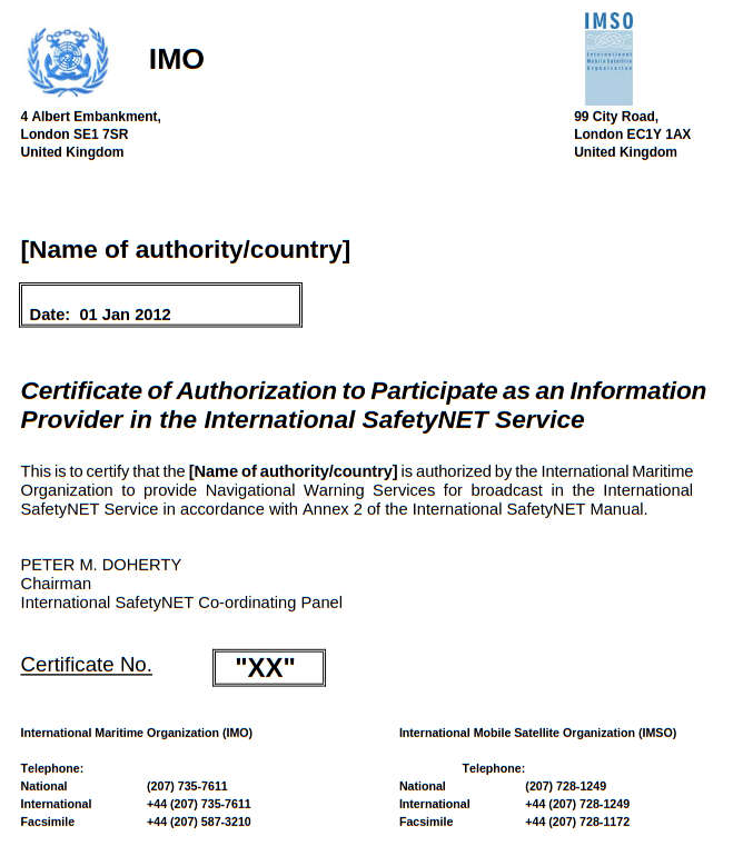
Certification
On receipt of IMO authorization, the International SafetyNET Coordinating Panel will issue a Certificate of Authorization to Participate in the International SafetyNET Service directly to the information provider with a copy to IHO or WMO or IMO, as well as to Inmarsat-C LES operators. A specimen Certificate of Authorization is shown at the end of this annex.
International SafetyNET Co-ordinating Panel will maintain the master list of all registered information providers and circulate it to IMO, IHO, WMO and all Inmarsat-C LES operators.
Registration
After receiving a Certificate of Authorization, an information provider may conclude an agreement with any Inmarsat-C LES operator(s), serving the required ocean region(s), to obtain access to the system.

This will involve, in addition to the contractual aspects, registration of the information provider’s identity which must be programmed into the LES control equipment. LES operators will only register information providers who have received a Certificate of Authorization.
Read also: The Global Maritime Distress and Safety System – Principles & Practice
Once authorized and registered, information providers should contact the LES operator(s) or service provider(s) they desire to use for promulgation of information to their areas of responsibility, in order to determine specific details for addressing messages, accessing the LES, charges and payment for services and any other matters with respect to providing MSI to mariners.
The International SafetyNET Coordinating Panel, in co-operation with IHO and WMO, undertakes the co-ordination of times for scheduled transmissions.
Mariners should be informed of the establishment of a SafetyNET service by the inclusion of full details in Notices to Mariners and other national nautical publications and the IMO Master Plan of Shore-Based Facilities for the GMDSS, as amended. In addition, full details of the service should be sent to the International SafetyNET Co-ordinating Panel at the address given below.
International SafetyNET Co-ordinating Panel
Terms of reference. To co-ordinate the development and use of the International SafetyNET Service, and in particular to:
- Develop operating methods for the effective use of the SafetyNET service, including consideration of the need for scheduled broadcasts;
- Develop documentation in support of the SafetyNET service, in particular the International SafetyNET Manual;
- Advise Land Earth Station (LES) operators and potential registered information providers on all aspects of the Service, including system access and effective operation;
- Develop criteria and establish means for the approval and registration of potential information providers;
- Co-ordinate the registration of potential information providers, and;
- Promote a proper understanding of the benefits and use of the International SafetyNET Service among the wider maritime community.
Contact address
The International SafetyNET Co-ordinating Panel can be contacted at the following address:
The Chairman
International SafetyNET Co-ordinating Panel
International Maritime Organization
4 Albert Embankment
London SE1 7SR
United Kingdom
Telephone: +44 (0)20 7735 7611, Telefax: +44 (0)20 7587 3210
E-mail: info@imo.org
Panel membership
The International SafetyNET Co-ordinating Panel is open to membership by all Member Governments and also includes one member nominated by each of the following international organizations:
- International Maritime Organization (IMO);
- World Meteorological Organization (WMO);
- International Hydrographic Organization (IHO);
- International Mobile Satellite Organization (IMSO).
The following may be represented as observers on the panel:
- IHO World-Wide Navigational Warnings Service Sub-Committee;
- IMO NAVTEX Co-ordinating Panel;
- Expert Team on Maritime Safety Services (ETMSS) of the Joint WMO/IOC Commission for Oceanography and Marine Meteorology (JCOMM);
- Inmarsat Global Limited.
Questions concerning promulgation of MSI through the EGC SafetyNET service can be addressed to the International SafetyNET Co-ordinating Panel at the address given above.
Changes to Existing SafetyNET Services
Registered information providers wishing to change their existing SafetyNET service should follow the same co-ordination procedures as for a new service, in accordance with the procedures set out above.
Mariners should be informed of the changes to an existing SafetyNET service by the inclusion of full details in Notices to Mariners and other national nautical publications and the IMO Master Plan of Shore-Based Facilities for the GMDSS, as amended. In addition, full details of the service should be sent to the International SafetyNET Co-ordinating Panel at the address given above.
Operation of the International SafetyNET Service
Given the size of a satellite ocean region, some form of selectivity in receiving and printing the various messages is required. All ships within the footprint of a selected satellite will receive area calls, however, they will only be displayed and printed by those receivers that recognize both:
- The fixed geographical area (NAVAREA/METAREA), user defined area as
appropriate, and; - For coastal warnings, the coastal warning area and the subject indicator for the message.
The message format includes a preamble which enables the EGC receiver to display and print only those MSI messages which relate to its present position, to the intended route, or to the afore mentioned areas as programmed by the operator.
For coastal warning areas messages, the MSI provider must ensure that the preamble includes the B1 Code identifier allocated for the particular area, along with the appropriate B2 Code subject indicator (See Maritime SafetyNET Service by Inmarsat“Exploring Maritime SafetyNET Service by Inmarsat”). The EGC receiver can be set to reject messages concerning certain optional subjects which may not be required by the ship (e. g. LORAN messages may be rejected in a ship which is not fitted with a Loran-C Receiver Features and Their UseLORAN receiver). Receivers also use the B2 Code subject indicator, to identify coastal warnings which, because of their importance, may NOT be rejected.
Reception of certain types of messages, such as shore-to-ship distress alerts, SAR information, meteorological warnings and forecasts and navigational warnings, addressed to a geographical area within which the EGC receiver is located, is mandatory and cannot be suppressed by ships in the affected area. These messages are identified by the C2 service codes: 00, 04, 14, 24, 31, 34 and 44 (See below).
Operational Guidance
This annex contains operational guidance for the benefit of registered MSI providers who are responsible for preparing messages for broadcast via the International SafetyNET Service.
Use of the codes given in this annex is mandatory for all messages in the system.
Types of messages and message formats are detailed in the sub-parts of this part of article.
- PART A – Navigational warning service;
- PART B – Meteorological service;
- PART C – Search and rescue (SAR) services and SAR coordination traffic;
- PART D – Piracy countermeasures broadcast messages;
Allocation of priority and service codes for EGC SafetyNET services | ||
---|---|---|
EGC SafetyNET service | Message priority | Service code (type) |
Navigational Warning services | C1 = 1 (Safety) – normally | C2 = 0.4 – Navigational warning to a rectangular area |
C1 = 2 (Urgency) – exceptionally at discretion of MSI provider | C3 = 13 – Coastal warnings | |
C5 = 24 – Navigational warnings to a circular area | ||
C6 = 31 – NAVAREA warnings | ||
Meteorological services | C1 = 1 (Safety) – always for forecasts and warnings | C2 = 0,4 – Meteorological warning to a rectangular area |
C1 = 2 (Urgency) – always for urgent tropical cyclone warnings only | C2 = 13 – Met warnings or forecasts to a coastal area | |
C3 = 24 – Met warnings to a circular area | ||
C5 = 31 – METAREA warnings or MET forecasts | ||
SAR services: 1) shore-to-ship distress alert | C1 = 3 (Distress) – always | C2 = 14 – Shore-to-ship Distress Alert to a circular area |
2) SAR co-ordination traffic | C1 = 1 (Safety) – determined by the phase of emergency | C2 = 34 – SAR co-ordination to a rectangular area |
C1 = 2 (Urgency) – determined by the phase of emergency | C3 = 44 – SAR co-ordination to a circular area | |
C1 = 3 (Distress) – determined by the phase of emergency | ||
3) shore-to-ship urgency & safety traffic | C1 = 1 (Safety) | C2 = 31 – Urgency and Safety traffic |
4) general (all ships call within the Inmarsat ocean region) | C1 = 2 (Urgency) | C2 = 00 |
Piracy countermeasures broadcast messages | C1 = 1 (Safety) | C2 = 0.4 – Navigational warning to a rectangular area |
C1 = 2 (Urgency) – for piracy attack warnings. | C2 = 13 – Coastal warnings | |
C3 = 24 – Navigational warnings to a circular area | ||
C5 = 31 – NAVAREA warnings |
The broadcast parameters are controlled by the use of five (or six) C-codes which are combined into a generalized message address header format as follows: C0:C1:C2:C3:C4:C5.
Spaces, colons or other delimiters between these codes will be required, depending on the communication protocol of the addressed LES.
Each C-code controls a different broadcast parameter and is assigned a numerical value according to the options specified in the following parts.
The additional C0 code will only be required to identify the satellite ocean region when sending a broadcast message to a LES which operates to more than one satellite ocean region, as follows:
- C0 = 0 – AOR-W;
- C0 = 1 – AOR-E;
- C0 = 2 – POR;
- C0 = 3 – IOR;
- C0 = 9 – All Ocean Regions. Subject to availability through LES or service provider.x
a All EGC messages should comprise of three elements:
Address header instruction (EGC C Codes)
TEXT OF MESSAGE
NNNN
Mandatory message element table | |
---|---|
Message Element | Remarks |
Address header instruction | The syntax of the special address header in relation to the exact number of digits and/or alphanumeric characters, and to the spaces between each C code is critical, and must conform to the format required by the LES or service provider as supplied in their specific instruction manual. |
TEXT OF MESSAGE | The content of the message should be presented in UPPER Case. For Maritime Safety Information messages, the format of Navigational Warnings is defined in the Joint IMO/IHO/WMO Maritime Safety Information Manual as amended. |
NNNN | The letters NNNN should be inserted at the end of the text to indicate “end of message“. |
b
EGC messaged submitted for transmission (or broadcast) via a two stage access system must also include an end of transmission instruction code for the LES. This should be inserted on the final line, after NNNN. This code may vary, and must conform to the format required by the LES or service provider as supplied in their specific instruction manual.
The International Maritime Organization (IMO) requires that, in order to allow the use of non-dedicated receive facilities, the majority of broadcasts on the International SafetyNET Service are made at scheduled times. Broadcast schedules must be co-ordinated through the International SafetyNET Co-ordinating Panel, which can also offer advice on ways of scheduling information within the system.
Because errors in the header format of a message may prevent it being released, MSI providers must install an Inmarsat SafetyNET receiver and monitor broadcasts of messages which they originate.
For all the services described below, a cancellation or deleting facility is provided for messages transmitted to a LES with Category (b) repetition codes (See Part E). Cancellation (or deletion) procedures may vary between different LESs or service providers. Detailed operational procedure is contained in the instructions on sending EGC broadcast given to the MSI providers after registration with the LES operator or service provider.
The term “echo” used in all of the services described below in Parts A, B, C & D, is associated with using the respective C4 repetition codes which will initiate an automatic repeated broadcast 6 minutes after the initial scheduled or unscheduled broadcast. The 6 minute repeat or echo is used to ensure that the warning is received by the maximum number of ships.
Part A – Navigational warning services
The following guidelines set out the arrangements to be used for promulgating navigational and coastal warnings via SafetyNET for the GMDSS. They are mandatory for broadcasts in the International SafetyNET Service. Broadcasts originated by the International Ice Patrol also follow the guidelines in this Part.
These guidelines are to be read in conjunction with the IMO/IHO World-Wide Navigational Warning Service (WWNWS) Guidance Document (IMO resolution A.706(17), as amended).
Navigational warnings that require an immediate broadcast should be transmitted as soon as possible after receipt. If still in force, they should be repeated in subsequent scheduled broadcasts, twice a day for six weeks or until cancelled.
Navigational warnings shall remain in force until cancelled by the originating Coordinator. Navigational warnings should be broadcast for as long as the information is valid; however, if they are readily available to mariners by other official means, for example in Notices to Mariners, then after a period of six weeks they may no longer be broadcast. If the navigational warning is still valid and not available by other means after 6 weeks, it should be re-issued as a new navigational warning.
The following C-codes shall be used for warnings issued under the auspices of the WWNWS.
C1 – Message priority |
---|
C1 = 1 (safety) |
C1 = 2 (urgency) (at discretion of the registered MSI provider) |
C2 – Service code | |
---|---|
C2 = 04 | NAVAREA warnings for a rectangular area |
C2 = 13 | Coastal warnings |
C2 = 24 | Navigational warnings to a circular area |
C2 = 31 | NAVAREA warnings |
C3 – Address code | |
---|---|
C3 = two digits X1 X2 | When C2 = 31, then: X1 X2 are the two digits of the NAVAREA number (with a leading zero where necessary in the range 01-21). |
C3 = four alphanumeric characters X1 X2 B1 B2 | When C2 = 13 for Coastal warnings, then: X1 X2 are the two digits of the NAVAREA number (with a leading zero where necessary in the range 01-21). B1 is the coastal warning area A to Z; B2 is the subject indicator must always be A or L, where: A = Navigational warnings; L = Other Navigational warnings. |
C3 = twelve alphanumeric characters D1 D2 La D3 D4 D5 Lo D6 D7 D8 D9 D10 | When C2 = 04 for NAVAREA warnings within a rectangular area. D1 D2 is latitude of south-west corner of the rectangle in degrees. La is hemisphere which will always be N for Arctic NAVAREAS XVII to XXI. D3 D4 D5 is longitude of south-west corner of rectangle in degrees, with leading zeros if required. Lo is longitude E or W. D6 D7 is extent of rectangle in latitude (degrees). D8 D9 D10 is extent of rectangle in longitude (degrees). |
Example: a rectangle whose south-west corner is 60° N and 010° W, extending 30° north and 25° east, is coded as: 60N010W30025. Note: latitude and longitude are limited by values from 00° to 90° latitude and 000° to 180° longitude. |
C4 – Repetition code | |
---|---|
C4 = 01 | May be used for initial unscheduled broadcast of NAVAREA warnings, and coastal warnings with no echo (transmit once on receipt). |
C4 = 11 | Recommended for use with initial unscheduled broadcast of NAVAREA warnings, and coastal warnings (transmit on receipt, echo 6 minutes later). |
C4 = 16 | Use for NAVAREA or Coastal warnings scheduled for broadcast twice per day at 12 hour intervals with safety priority. |
Note. For NAVAREA or Coastal warnings scheduled for broadcast more than twice per day, the appropriate C4 repetition code detailed in PART E of this article must be used. |
C5 – Presentation code | |
---|---|
C5 = 00 | The code 00 for International Alphabet Number 5 is normally used. |
Part B – Meteorological services
The following guidelines set out the arrangements to be used for promulgating meteorological forecasts and warnings via SafetyNET for the GMDSS. They are mandatory for broadcasts in the International SafetyNET Service.
These guidelines are to be read in conjunction with the WMO Manual on Marine Meteorological Services (WMO No. 558), as revised for the GMDSS.
In order to ensure uniformity of meteorological forecasts and warnings globally, the following C-codes should be used for meteorological services via SafetyNET.
C1 – Message priority | |
---|---|
C1 = 2 (urgency) | Only use for tropical cyclone warnings or urgent meteorological warnings with force 12 Beaufort or above. |
C1 = 1 (safety) | For forecasts and other meteorological warnings. |
C2 – Service code | |
---|---|
C2 = 24 | Meteorological warnings to a circular area |
C2 = 31 | Meteorological warnings or forecasts to METAREA |
C2 = 13 | Meteorological warnings or forecast to coastal warning area |
C2 = 04 | METAREA warnings or forecasts for a rectangular area |
C3 – Address code | |
---|---|
C3 = ten alphanumeric characters D1 D2 La D3 D4 Lo R1 R2 R3 | When C2 = 24 for Meteorological warnings to user defined circular area, then: D1 D2 La (three characters) is latitude of centre in degrees, and La whether north (N) or south (S). A leading zero should be used for latitudes less than 10°. D3 D4 D5 Lo (four characters) is longitude of centre in degrees, and Lo whether east (E) or west (W) of the prime meridian. One or two leading zeros should be used for longitudes less than 100°. R1 R2 R3 (three characters) is radius of circle in nautical miles, up to 999. One or two leading zeros should be used for radius less than 100 nm. |
Example: A circle centred at latitude 56°N longitude 34°W with radius of 35 nautical miles is coded as: 56N034W035 | |
C3 = two digits XX | When C2 = 31, then: C3 = the two digits of the METAREA number (with a leading zero where necessary in the range 01 – 21). |
C3 = four alphanumeric characters X1 X2 B1 B2 | When C2 = 13 for Coastal warnings, then: X1 X2 are the two digits of the METAREA number (with a leading zero where necessary in the range 01 – 21). B1 is the coastal warning area A to Z B2 is the subject indicator must always be B or E, where: B = Meteorological warnings E = Meteorological forecasts |
C3 = twelve alphanumeric characters D1 D2 La D3 D4 D5 Lo D6 D7 D8 D9 D10 | When C2 = 04 for Meteorological warnings or forecasts within a rectangular area. Note: The definition of 12 characters for a Rectangular address is given in Part A. |
C4 – Repetition code | |
---|---|
Category (a) repetition codes are used for meteorological services as follows: | |
C4 = 01 | Use for Meteorological forecast (transmit once on receipt) |
C4 = 11 | Use for Meteorological warning (transmit on receipt followed by repeat 6 minutes later) |
C5 – Presentation code | |
---|---|
C5 = 00 | The code 00 for International Alphabet Number 5 is normally used |
Part C – Search and rescue services
The following guidelines set out the arrangements to be used by Rescue Co-ordination Centres (RCCs) for initiating transmission of shore-to-ship distress alert relays and shore-to-ship search and rescue information. Transmissions should be in accordance with the relevant procedures of the International Telecommunication Union (ITU) Radio Regulations (RR), the International Convention on Maritime Search and Rescue, 1979, as amended, and the IAMSAR Manual.
In order to ensure uniformity of the search and rescue broadcast product throughout the world, C-codes should be used as described in this Part.
Shore-to-ship distress alert relays. As a general principle, distress alert relays should be addressed to a circular area around the estimated or known position of the distressed vessel. The radius of the circle should be chosen to take account of the accuracy of the datum position, the expected density of shipping in the vicinity and the fact that the position can only be defined in the message address to the nearest whole degree of latitude and longitude. The distress alert relay message must be broadcast via all satellites which cover the area concerned. Shore-to-ship distress alert relays sent by the International SafetyNET Service should contain the identification of the unit in distress, its approximate position and other information which might facilitate rescue. C-codes should be as follows:
C1 – Message priority | |
---|---|
C1 = 3 |
C2 – Service code | |
---|---|
C2 = 14 (shore-to-ship distress alert to circular areas) | Messages addressed to circular areas will only be received and printed out by EGC receivers that are located inside the circle or have not had their position kept up to date. |
C3 – Address code | |
---|---|
C3 = ten alphanumeric characters D1 D2 La D3 D4 D5 Lo R1 R2 R3 | When C2 = 14 for Distress Alert to user defined circular area, then: D1 D2 La (three characters) is latitude of vessel in distress in degrees (two digits) and whether north (N) or south (S): e. g., 39N (three characters total). A leading zero should be included for latitudes less than 10°. D3 D4 D5 Lo (four characters) is longitude of vessel in distress in degrees (three digits) and whether east (E) or west (W) of the prime meridian: e. g. 059W. A leading zero or zeros should be included for longitudes less than 100° or 10° as appropriate: e. g., use 099 for 99° and 008 for 8°. R1 R2 R3 (three characters) is alert radius around distressed vessel in nautical miles. To ensure that position inaccuracies of both the distressed vessel and nearby vessels to which the message is intended do not affect receipt of messages, radius values of 200 nautical miles or larger should normally be used. Note that if a vessel’s own position information is not entered into its SafetyNET receiver, every shore-to-ship distress alert relay message transmitted to the Inmarsat ocean region will be received and printed. |
C4 – Repetition code | |
---|---|
C4 = 11 | Use for Distress Alerts (transmit on receipt followed by repeat 6 minutes later) |
C5 – Presentation code | |
---|---|
C5 = 00 | The code 00 for International Alphabet Number 5 is normally used |
General (all ships) call. When the RCC has no indication of the position of the vessel in distress, shore-to-ship distress alert relays may be sent as general call. This will be printed in every vessel within the Inmarsat ocean region, provided the receiver is tuned to the proper ocean region satellite.
Note: This method of alert should rarely be used.
The C0:C1:C2:C3:C4:C5 codes for general calls are always as follows:
- C0 = 0 (1, 2 or 3) (if required);
- C1 = 3 (distress) or 2 (urgency);
- C2 = 00;
- C3 = 00;
- C4 = 11;
- C5 = 00.
Search and rescue co-ordination traffic. Search and rescue co-ordination messages should be addressed to user defined circular or rectangular areas for the intent of co-ordinating the search and rescue of a vessel in distress. Priority of the message will be determined by the phase of the emergency.
C1 – Message priority | |
---|---|
C1 = 3 (distress), 2 (urgency) or 1 (safety) |
C1 – Message priority | |
---|---|
C2 = 34 | Search and rescue coordination to a rectangular area |
C2 = 44 | Search and rescue coordination to a circular area |
C3 – Address code | |
---|---|
C3 = twelve alphanumeric characters D1 D2 La D3 D4 D5 Lo D6 D7 D8 D9 D10 | When C2 = 34 Search and rescue coordination to a rectangular area. Note: The definition of 12 characters for a Rectangular address is given in Part A. |
C3 = ten alphanumeric characters D1 D2 La D3 D4 D5 Lo R1 R2 R3 | When C2 = 44 Search and rescue coordination to a circular area. Note: The definition of 10 characters for a circular address is given in Part C. |
C4 – Repetition code | |
---|---|
C4 = 11 | Use for Distress Alerts (transmit on receipt followed by repeat 6 minutes later) |
C5 – Presentation code | |
---|---|
C5 = 00 | The code 00 for International Alphabet Number 5 is normally used |
Shore-to-ship urgency and safety traffic. As a general principle, only the minimum information consistent with the safety of navigation should be broadcast. However, where such information is deemed essential, shore-to-ship information other than distress should be broadcast to a NAVAREA using C-codes as follows:
C1 – Message priority | |
---|---|
C1 = 2 (urgency) or 1 (safety) |
C2 – Service code | |
---|---|
C2 = 31 |
C3 – Address code | |
---|---|
C3 = two digits X1 X2 | When C2 = 31, then: X1 X2 are the two digits of the NAVAREA number (with a leading zero where necessary in the range 01 – 21). |
C4 – Repetition code | |
---|---|
C4 = 11 | Use for unscheduled broadcasts of urgency and safety traffic (transmit on receipt followed by repeat 6 minutes later) |
C5 – Presentation code | |
---|---|
C5 = 00 | The code 00 for International Alphabet Number 5 is normally used |
SAR broadcast for overlapping satellite ocean regions. Search and rescue distress and urgency broadcasts should be promulgated through all Inmarsat satellites serving the area surrounding the vessel in distress. This is to ensure that vessels with receivers tuned to any ocean region satellite serving the area will receive the message.
Part D – Piracy countermeasures broadcast messages
On receiving a message of alert or any other information concerning a threat of attack (from the Security Forces Authority responsible for the operational application of the urgency plans (countermeasures) in the region or another MRCC, for example), the MRCC should ask the NAVAREA co-ordinator (or any other competent authority in accordance with local arrangements), to send out a warning through the appropriate MSI network (NAVTEX or SafetyNET) and other broadcasting networks for warnings to shipping, if these exist.
There are two kinds of MSI broadcast messages associated with piracy countermeasures: the daily situation report (SITREP) and a piracy attack warning. Specific guidance on drafting and broadcasting these messages is given below.
The daily situation report should be broadcast via SafetyNET at a regular time around 0800 local time daily. The following paragraphs provide specific guidance on broadcast procedures.
The daily situation report should be broadcast to a rectangular area enclosing the region of probable piracy attacks (based on historical data) plus a margin of 700 nautical miles (24 hours steaming by a fast ship) in every direction.
The following C codes illustrate those to be used for SafetyNET broadcasts of the daily SITREP:
C1 – Message priority | |
---|---|
C1 = 1 (safety) |
C2 – Service code | |
---|---|
C2 = 04 | SITREP to a rectangular area |
C2 = 24 | SITREP to a circular area |
C3 – Address code | |
---|---|
C3 – twelve alphanumeric characters D1 D2 La D3 D4 D5 Lo D6 D7 D8 D9 D10 | When C2 = 04 SITREP to a rectangular area. Note: The definition of 12 characters for a Rectangular address is given in Part A. |
C3 – ten alphanumeric characters D1 D2 La D3 D4 Lo R1 R2 R3 | When C2 = 24 SITREP to a circular area. Note: The definition of 10 characters for a circular address is given in Part C. |
C4 – Repetition code | |
---|---|
C4 = 18 | Broadcast every 24 hours (no echo) until cancelled |
C5 – Presentation code | |
---|---|
C5 = 00 | The code 00 for International Alphabet Number 5 is normally used. |
A piracy attack warning shall be broadcast as an “URGENT” NAVAREA or Coastal Warning immediately on receipt of the source information and at least at the next scheduled broadcast or for as long as the information remains valid. In the area of overlap coverage from two or three ocean region satellites, urgent warnings will be broadcast over all satellites which cover the affected region.
Subject indicator character B2 = L should be used in Coastal Warning areas. The specific area in which the attack has taken place is to be quoted in the first line of the text, using no more detail than is necessary to indicate the probable location of further attacks, e. g., WESTERN PHILIP CHANNEL or VICINITY HORSBURGH LIGHT. The description of the pirate vessel and its last observed movements are to be kept as brief as possible and should give only those details which are of significance in avoiding other attacks.
The following C codes illustrate those to be used for SafetyNET broadcast of Piracy attack warnings:
C1 – Message priority | |
---|---|
C1 = 2 (urgency) |
C2 – Service code | |
---|---|
C2 = 13 | Coastal Warnings |
C2 = 31 | NAVAREA Warnings |
C3 – Address code | |
---|---|
C3 = two digits X1 X2 | When C2 = 31 then: X1 X2 are the two digits of the NAVAREA number (with a leading zero where necessary in the range 01 to 21). |
C3 = four alphanumeric characters X1 X2 B1 B2 | When C2 = 13 for Coastal warnings then: X1 X2 are the two digits of the NAVAREA number (with a leading zero where necessary in the range 01 to 21). B1 is the coastal warning area A to Z. B2 is the subject indicator and must always be A or L, where: A = Navigational warnings L = Other navigational warnings |
C4 – Repetition code | |
---|---|
C4 = 16 | Broadcast every 12 hours with no echo until cancelled |
C5 – Presentation code | |
---|---|
C5 = 00 | The code 00 for International Alphabet Number 5 is normally used. |
Date/time should always be quoted in the form DDHHMM UTC MoMoMo YY, e. g., 251256 UTC JUN 12.
Note: UTC (Universal Co-ordinated Time) is the same time-zone as GMT (Z).
Geographical positions should be quoted in the standard format: D1 D2 M1 M2 La D3 D4 D5 M3 M4 Lo where:
- D1 D2 = degrees latitude (with leading zero if required);
- M1 M2 = minutes latitude;
- La = hemisphere (N or S);
- D3 D4 D5 = degrees longitude (with leading zeros if required);
- M3 M4 = minutes longitude;
- Lo = longitude (E or W).
as in the example: 5419N10327E.
Notes:
- Examples of format and drafting guidance for Piracy Warnings is contained in the Joint IMO/IHO/WMO Manual on Maritime Safety Information (IMO MSC.1/Circ.1310 and IHO Special Publication No. S53.).
- Decimals of minutes will seldom be necessary or appropriate for reports of this kind.
- Where the name of a geographical feature is used instead of a geographical position, a name should be chosen that appears on all commonly used charts of the area. Local knowledge should not be required for understanding the message.
Part E – Repetition codes (C4)
The C4 repetition codes are divided into two categories:
- Category (a) for messages that are required to be repeated a finite number of times, and;
- Category (b) for messages that are required to be repeated at specified intervals until cancelled by the MSI provider.
Category (a) repetition codes:
Code | Instruction |
---|---|
01 | transmit once on receipt |
11 | transmit on receipt followed by repeat 6 minutes later |
61 | transmit on receipt and 1 hour after initial broadcast (twice) |
62 | transmit on receipt and 2 hour after initial broadcast (twice) |
63 | transmit on receipt and 3 hour after initial broadcast (twice) |
64 | transmit on receipt and 4 hour after initial broadcast (twice) |
66 | transmit on receipt and 12 hour after initial broadcast (twice) |
67 | transmit on receipt and 24 hour after initial broadcast (twice) |
70 | transmit on receipt, 12 hours after initial broadcast and then 12 hours after the second broadcast (three times) |
71 | transmit on receipt, 24 hours after initial broadcast and then 24 hours after the second broadcast (three times) |
Category (b) repetition codes: a Category (b) repetition code allows a message to be repeated indefinitely or until cancelled by the message provider. The repetition period can be set at between 1 and 120 hours. In addition, each transmission can be echoed after a fixed period of 6 minutes.
Repetition codes are made up by stating the multiplier first, followed by the delay period:
where the multiplier specifies the amount of delay periods between each broadcast, and the delay is a fixed number of hours.
The multiplier digit may be any digit from 1 to 5 as follows:
- 1 = 1 specified delay period between broadcasts;
- 2 = 2 specified delay periods between broadcasts;
- 3 = 3 specified delay periods between broadcasts;
- 4 = 4 specified delay periods between broadcasts;
- 5 = 5 specified delay periods between broadcasts.
The delay digit coding is as follows:
- 2 = 1 hour delay; no echo;
- 3 = 1 hour delay; with echo;
- 4 = 6 hour delay; no echo;
- 5 = 6 hour delay; with echo;
- 6 = 12 hour delay; no echo;
- 7 = 12 hour delay; with echo;
- 8 = 24 hour delay; no echo;
- 9 = 24 hour delay; with echo.
The various combinations (Multiplier · Delay) available, are shown in the table below:
Code | Instruction |
---|---|
12 | repeat broadcast every 1 hour with no echo. |
13 | repeat broadcast every 1 hour with an echo 6 minutes after each broadcast. |
22 | repeat broadcast every 2 hours with no echo. |
23 | repeat broadcast every 2 hours with an echo 6 minutes after each broadcast. |
32 | repeat broadcast every 3 hours with no echo. |
33 | repeat broadcast every 3 hours with an echo 6 minutes after each broadcast. |
42 | repeat broadcast every 4 hours with no echo. |
43 | repeat broadcast every 4 hours with an echo 6 minutes after each broadcast. |
52 | repeat broadcast every 5 hours with no echo. |
53 | repeat broadcast every 5 hours with an echo 6 minutes after each broadcast. |
14 | repeat broadcast every 6 hours with no echo. |
15 | repeat broadcast every 6 hours with an echo 6 minutes after each broadcast. |
16 (or 24) | repeat broadcast every 12 hours with no echo. |
17 (or 25) | repeat broadcast every 12 hours with an echo 6 minutes after each broadcast. |
34 | repeat broadcast every 18 hours with no echo. |
35 | repeat broadcast every 18 hours with an echo 6 minutes after each broadcast. |
18 (or 26; or 44) | repeat broadcast every 24 hours with no echo. |
19 (or 27; or 45) | repeat broadcast every 24 hours with an echo 6 minutes after each broadcast. |
54 | repeat broadcast every 30 hours with no echo. |
55 | repeat broadcast every 30 hours with an echo 6 minutes after each broadcast. |
36 | repeat broadcast every 36 hours with no echo. |
37 | repeat broadcast every 36 hours with an echo 6 minutes after each broadcast. |
28 (or 46) | repeat broadcast every 48 hours with no echo. |
29 (or 47) | repeat broadcast every 48 hours with an echo 6 minutes after each broadcast. |
56 | repeat broadcast every 60 hours with no echo. |
57 | repeat broadcast every 60 hours with an echo 6 minutes after each broadcast. |
38 | repeat broadcast every 72 hours with no echo. |
39 | repeat broadcast every 72 hours with an echo 6 minutes after each broadcast. |
48 | repeat broadcast every 96 hours with no echo. |
49 | repeat broadcast every 96 hours with an echo 6 minutes after each broadcast. |
58 | repeat broadcast every 120 hours with no echo. |
59 | repeat broadcast every 120 hours with an echo 6 minutes after each broadcast. |
Note – Not all codes may be provided by all service providers.
When a message has been received error-free, a record is made of the message identification (the unique sequence number, the LES identifier and the service code) associated with that message. The unique sequence number is used to suppress the printing of repeated transmissions of the same message.
An EGC receiver is capable of storing at least 255 message identifications. These message identifications are stored with an indication of the number of hours that have elapsed since the last receipt of the message. Subsequent reception of the same message identification will reset this timer. After between 60 and 72 hours, message identifications may be automatically erased. If the number of received message identifications exceeds the capacity of memory allocated, the oldest message identification will be erased.
SafetyNET messages can be addressed to user defined areas, which may be circular or rectangular in shape. A circular area is described by latitude and longitude of the centre in degrees and radius of the circle in nautical miles. A rectangular area is described by latitude and longitude of the southwest corner in degrees and extension in degrees to the North and East of the rectangle.
In the case of a ship in distress, it is normal to create a circular user defined area (C2 service code 14), defined by the position of the casualty and a radius around the casualty to alert ships that may be able to render assistance (See Figure 5).

If no response is received from any ship at the first call, the area can be expanded in steps until an acknowledgement by one or more ships is received. In cases where the position of the distress is unknown, a shore to ship distress alert can be transmitted to all ships (C2 service code 00), in a given satellite ocean region. SAR co-ordination messages shall only be addressed to circular (C2 service code 14) or to rectangular (C2 service code 34) user defined areas (See Figure 6).

Promulgation of Maritime Safety Information
Maritime safety information is promulgated by officially registered information providers whose Certificates of Authorization to broadcast via SafetyNET are issued by the IMO in accordance with the procedures above.
Registered information providers include for example:
- NAVAREA Co-ordinators: for NAVAREA warnings and other urgent safety-related information;
- National Co-ordinators: for coastal warnings and other urgent safety-related information;
- METAREA issuing services: for meteorological warnings and forecasts, and;
- Rescue Co-ordination Centres: for shore-to-ship distress alerts, SAR information and other urgent safety-related information.
All METAREA/NAVAREA, Sub-Area and coastal warnings shall be broadcast only in English in the international SafetyNET service in accordance with IMO resolution A.706(17), as amended. In addition to the required broadcasts in English, METAREA/NAVAREA, Sub-Area and coastal warnings may be broadcast in a national language using a national SafetyNET service.
Registered information providers shall take into account the need for contingency planning.
The Inmarsat system
Introduction
There are three essential components of the Inmarsat system:
- The Inmarsat space segment – the satellites and their ground support facilities – planned and funded by Inmarsat;
- The ground segment – comprises a network of Land Earth Stations (LESs), Network Coordination Stations (NCSs) and the Network Operations Centre (NOC). Each LES provides an interface between the space segment and the national and international fixed telecommunication networks, and;
- The Mobile Earth Stations (MESs) – comprises mobile satellite communication terminals.
Bandwidths. Shore-to-ship communications are in the 6 GHz band (C-band) from the LES to the satellite and in the 1,5 GHz band (L-band) from satellite to ship. Ship-to-shore communications are in the 1,6 GHz band (L-band) from the ship to the satellite and in the 4 GHz band (C-band) from satellite to LES.
The space segment
To provide the space segment for global coverage, Inmarsat employs its own dedicated satellites.
The space segment is segmented globally into four ocean regions:
- Atlantic Ocean Region East (AOR-E);
- Atlantic Ocean Region West (AOR-W);
- Indian Ocean Region (IOR) and;
- Pacific Ocean Region (POR).
Each ocean region is served by a dedicated satellite. Inmarsat has full contingency plans in place in the unlikely event of any prime satellite outage. These plans are exercised regularly and are witnessed by the International Mobile Satellite Organization (IMSO). The Polar Regions – above approximate latitudes 76° N and 76° S – cannot be seen by geostationary satellites (See Figures 3 & 4).
The ground segment
The Inmarsat system is connected into the world-wide telecommunication networks via LESs. Many of these LESs provide Inmarsat-C EGC services.
For Inmarsat-C communication system there is a Network Coordination Station (NCS) in each ocean region, which monitors and controls communications traffic within its region. Each NCS communicates with the LESs in its ocean region, the other NCSs and the Network Operations Centre (NOC). Inmarsat-C NCSs also transmit EGC SafetyNET and FleetNET messages on the NCS common channel.
The Inmarsat Network Operations Centre (NOC) is located in London at the Inmarsat headquarters and functions around the clock, co-ordinating the activities of the NCSs and the LESs in each ocean region.
Mobile Earth Stations (MESs)
Inmarsat-C and mini-C MESs with the EGC function are small, lightweight terminals, with small omni-directional antennas, for providing data and message-type services. EGC receive capability is provided by Class 2 or 3 Inmarsat-C MESs. Interfaces via RS232 ports are provided for a dedicated messaging unit, personal computer or any other data terminal equipment for message generation and display.
Class 0 standalone EGC receivers provide the capability to receive SafetyNET and FleetNET messages only; there is no transmit or receive capability for sending and receiving messages.
The technical requirements of all classes of equipment are detailed in Maritime SafetyNET Service by Inmarsat“Exploring Maritime SafetyNET Service by Inmarsat”.
Procedure for amending the International SafetyNET Manual
Proposals for amendment or enhancement of the International SafetyNET Manual should be submitted to the IMO Maritime Safety Committee through the Sub-Committee on Radiocommunications and Search and Rescue.
Amendments to this Manual should normally come into force at intervals of approximately two years or at such longer periods as determined by the Maritime Safety Committee at the time of adoption. Amendments adopted by Maritime Safety Committee will be notified to all concerned, will provide at least 12 months notification and will come into force on 1 January of the following year.
The agreement of the International Hydrographic Organization, International Mobile Satellite Organization, the World Meteorological Organization and the active participation of other bodies should be sought, according to the nature of the proposed amendments.