Discover how the Inmarsat Mobile Number system works and learn about the commissioning process. We’ll also explore how Inmarsat compares to other satellite communication systems, making it the go-to choice for many in the maritime industry.
We’ll also delve into Inmarsat Mobile Numbers. Discover how Inmarsat empowers seafarers with reliable voice, data, and safety services, enhancing their operations and ensuring their well-being.
Satellite communication facilities are provided by the International Maritime Satellite Organization, Inmarsat. The organization was founded on September 3,1976, and today numbers 86 member countries, with more countries in the process of joining.
In 1982 Inmarsat-A was the first Inmarsat system introduced into global commercial operation. The organization’s main task is to provide satellite-based services for maritime communication, and to improve distress and safety services.
Since 1982 Inmarsat has expanded, and today they also offer services for mobile land-based users and aeronautical users.
A total of over 20 000 Inmarsat-A terminals are now in use world-wide.
Inmarsat-B, which was introduced in 1994, provides the same services and is intended to be the successor to Inmarsat-A, although the two systems will co-excist for many years.
Inmarsat-C was introduced in 1991 to complement the Inmarsat-A system. This system does not provide voice communications, but does provide a means of sending text messages and data to and from a SES. The combination of global communication capability combined with its MSI broadcasting and distress capabilities has resulted in Inmarsat-C being accepted by the International Maritime Organization (IMO) as a part of the GMDSS. Similarly, the Inmarsat-A and Inmarsat-B systems have also been accepted.
The Inmarsat-M system was introduced in December 1992 to complement the excising services. This system provides global two-way telephone, fax and computer data communications. The Inmarsat-M system, however, has not yet been approved for use in the GMDSS.
And finally, there is the Inmarsat-E system, which makes use of the existing Inmarsat infrastructure to provide a cost-effective means of distress alerting, using an L-band EPIRB (Emergency Position Indicating Radio Beacon) for ship-to-shore GMDSS Distress and Safety Communicationsdistress alerting over the Inmarsat space segment.
A General Overview
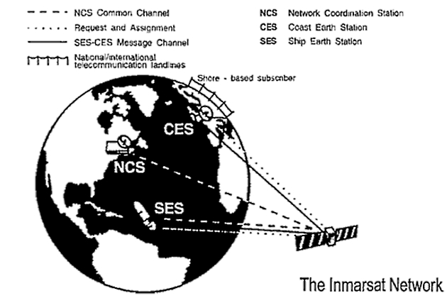
The Inmarsat system consists of three major components.
a Satellite capacity – provided by Inmarsat.
b Coast Earth Stations (CES) – provided by the Inmarsat signatories.
c Ship Earth Stations (SES), Land-mobile Earth Stations (LMESs) and Aircraft Earth Stations (AESs).
The “heart” of the system is the NETWORK OPERATIONS CENTRE (NOC) located at Inmarsat headquarters in London. Operating 24 hours a day, it monitors, co-ordinates and controls the operational activities of all satellites in the network. The NOC also arranges the commissioning of the ship-earth stations upon application from the shipowner.
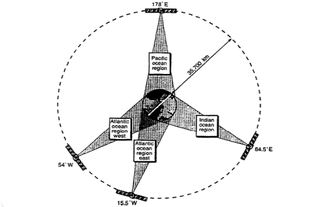
The regions covered by the four satellites are:
| AORW | Atlantic Ocean region West |
| AORE | Atlantic Ocean region East |
| IOR | Indian Ocean Region |
| POR | Pacific Ocean Region |
| Inmarsat Ocean Region Access Codes | ||
|---|---|---|
| Ocean Region | Telex | Telephone |
| AOR-E | 581 | 871 |
| POR | 582 | 872 |
| IOR | 583 | 873 |
| AOR-W | 584 | 874 |
In order to call a SES in an Ocean Region, telex or telephone access codes must be used.
The space segment
Inmarsat satellites are placed in geostationary orbit 35 700 kms over the major ocean regions. In this orbit, each satellite moves at exactly the same rate as the rotation of the earth, and thus remains in the same relative position to the earth, above the earth’s equator. The satellites are equipped with solar panels providing electrical power and thus enabling them to perform their functions.
Read also: DSC (Digital Selective Calling) Procedures for VHF – MF and HF
In the above-mentioned position, the satellites achieve almost global coverage with the exception of the polar regions above 76 degrees North and below 76 degrees South.
Within the polar areas, it is not possible to see a satellite in geostationary orbit. The system always includes one operative satellite, and one on standby as a back-up incase of malfunctions. Since the beginning there has been an increasing need for special services and greater capacity. Therefore, Inmarsat continuously develops new requirements for satellites, and the newest generation of satellites is able to handle up to 400 simultaneous telephone calls, or several thousand messages from ship terminals.
Coast Earth Stations (CES)
The term CES is included in the generic category LAND EARTH STATION (LES), which applies to the earth stations used for either maritime or land-based communication. It is the system name given to the Inmarsat earth stations located in different countries throughout the world, through which ship-earth stations can route their traffic.
Each CES acts as the communication gateway between the Inmarsat network and the International Telecommunication Network.
A CES operator is typically a large telecommunications company, which can provide a wide range of communication services to the SESss communicating through the CES. At present there are 31 CESs in existence worldwide. They are owned and operated by the respective countries’ public telecommunications authorities. A typical CES consists of a parabolic dish antenna with a diameter of 11 to 14 meters, which is used for the transmission of signals to the satellite on 6 GHz, and reception from the satellite on 5 GHz. The same antenna, or another dedicated one, is used for the transmission of network control signals on 1,6 GHz and reception of these on 1,5 GHz (L-band). As a minimum, each CES provides distress, TELEX (Narrow Band Direct Printing – NBDP) Procedurestelex and telephone services.
Network Co-ordinating Station (NCS)
Each Empowering Global Communication with INMARSAT Satellites in shippingInmarsat system has a Network Co-ordinating Station (NCS) located within each ocean region. The NCS acts as a type of switch operator; assigning, controlling and monitoring all of the telephone and telex channels between the SES and the CES in their own ocean regions.
Inmarsat-A SESs must always monitor the Common Signalling Channel (TDMO) in order to receive and transmit channel assignments. A second channel (TDM1), available in all four ocean regions, was introduced in July 1993. This second channel has improved access time, particularly during peak hours.
Inmarsat-A SESs with an even fourth digit in their main IMN are to monitor TDMO, while SESs with an odd fourth digit in their main IMN are to monitor TDM1.
Ship Earth Station (SES)
The term SES is included in the generic category of MOBILE EARTH STATIONS (MES), which applies to all Inmarsat terminals. As mentioned earlier, the Inmarsat-A terminal is used for the transmission and reception of distress traffic, telex, telephone and facsimile calls.
Before an Inmarsat-A SES can be used in the Inmarsat system, it must have been properly installed and commissioned. Only after successful commissioning will Inmarsat permit the SES to access the system.
As mentioned earlier, all SESs are assigned an Inmarsat Mobile Number (IMN), as an identity number. For Inmarsat-A terminals this number consists of seven digits. About 20 % or more of the vessels fitted with Inmarsat-A terminals have two IMNs, depending on which SES model the ship is equipped with.
a) Single-channel SES: A single-channel SES is capable of using any one of its communication services at a time (for example telephone, telex, fax or data), but no more than one.
b) Multi-channel SES: A multi-channel SES is capable of using more than one service on different channels, at the same time – for example one channel can be making a telephone call, while, at the same time, another channel can be receiving a fax.
Inmarsat Mobile Number
To obtain access to the system a SES or a terrestrial unit must be programmed with an identity number. The identity number is called an Inmarsat Mobile Number (IMN). Inmarsat-A terminal IMNs are generated by the Inmarsat Commissioning Department in London, while Inmarsat-B, C and M numbers are assigned by the national routing organization.
| Numbering in the GMDSS | |
|---|---|
| Inmarsat-A | 1 MID-A Z1 Z2Z3* |
| Inmarsat-B | 3 MID XXX ZZ |
| Inmarsat-C | 4 MID XXX ZZ |
| Inmarsat-M | 6 MID XXX ZZ |
| * MID-A is the three digit Maritime Identification (MID) Country code, for the SES’ country of registration. The MID-A codes are given in the Inmarsat Commissioning Procedures manual. Z1 may be any number between 1 and 7. Z2Z3 may be any number between 01 and 77. Norway is assigned the MID-A series 310 to 317. | |
The numbering of Inmarsat-B, C and M is derived from the ships MMSI number. MID XXX (X) represents the first 6 or 7 digits of the MMSI number. MID is the three digit Maritime Identification Digit of the ship indicating its country of registration. XXX identifies the vessel, and ZZ is used for addressing several other services, such as telephone and telefax, or computer terminals on board the ship, and can be any number between 10 and 99.
Inmarsat Commissioning
Every new ship-earth-station (SES) that is to be used in an Inmarsat system, must first complete a process known as commissioning, before Inmarsat can permit the SES to access the system. The purpose of commissioning is to ensure that the SES is registered in the Inmarsat system, and is tested to confirm that it can communicate properly without causing interference to the system, or to other users.
Commissioning application
To register a new SES, a commissioning application must be forwarded to the national routing organization. The application form contains information about the SES model, country of registration, installation, owner and accounting arrangements.
Commissioning tests
When all the formalities are taken care of, the owner of the SES will receive a confirmation from the Inmarsat commissioning department or from the routing organization with identity details (IMN) and instructions regarding the commissioning tests.
It will interesting: Regulations and Traffic Procedures
Approximately 24 hours later, the commissioning tests may be performed, and normally access to the Inmarsat system will then be granted. During the following 24 hours, traffic must be forwarded through the commissioning CES in order to give Inmarsat time to download a file with the data to all the CESs in the system.
Inmarsat-A commission tests require special instruments, while no instruments are required when commissioning the other systems. The above procedure must be conducted when installing a new terminal, when major changes have been made to an old one, or when changing a ship’s flag/registry.
Decommissioning
If an Inmarsat terminal is to be sold after initial commissioning, or as previously mentioned after change of flag, the terminal has to be decommissioned. This means that the terminal is taken out of the Inmarsat system and then recommissioned i. e. re-entered into the system with a new identity.
If a terminal is decommissioned or barred for some reasons, it can not be used for commercial traffic. The distress function will, however, remain in operation and can be used except when the terminal is barred due to malfunction.
Inmarsat system comparisons
The following table provides a detailed comparison of the physical and technical characteristics of each of the Inmarsat systems:
| Inmarsat system comparisons | ||||
|---|---|---|---|---|
| Features | Inmarsat-A | Inmarsat-B | Inmarsat-C | Inmarsat-M |
| World Coverage | Global | Global | Global | Global |
| Overall weight | Average 100 kg | Average 100 kg | Average 4 kg | Average 25 kg |
| Size of antenna | Approx. 0,9-1,2 m | Approx. 0,9 m | Approx. 0,3 m | Approx. 0,5 m |
| Antenna type and means of tracking | Parabolic antenna mechanically steered and gyro stabilised against vessel motion | Same as Inmarsat-A | Smallomni directional antenna with no moving parts | Same as Inmarsat A/B |
| Communication type | Real time (immediate) | Real time | Store and forward | Real time |
| Services | ||||
| Voice | Yes | Yes | No | Yes |
| Telex | Yes | Yes | Yes | No |
| Group 3 fax rates | To 9,600 bps | To 9,600 bps | No | To 2,400 bps |
| Data rates | To 9,600 bps | To 9,600 bps | 600 bps | To 2,400 bps |
| X-25 (Dedicated data channel) | Yes | Yes | Yes | Yes |
| X-400 (Electronic Mail) | Yes | Yes | Yes | Yes |
| High speed data | 56 764 kbps | 56 764 kbps | No | No |
| Full motion «store and forward» video | Yes | Yes | No | No |
| Short data position | No | No | Yes | No |
| Group Call | Yes | Yes (enhancement) | Yes | Yes (enhancement) |
| SafetyNet | Yes, if Inmarsat-C/EGC Receiver installed | Yes, if Inmarsat-C/EGC receiver installed | Yes | Yes, if Inmarsat-C/EGC Receiver installed |
| FleetNet | Yes, if Inmarsat-C/EGC Receiver installed | Yes, if Inmarsat-C/EGC Receiver installed | Yes | Yes, if Inmarsat-C/EGC Receiver installed |
| Distress and Safety | ||||
| GMDSS Compliant | Yes, if properly installed——————————> | No | ||
| Distress Button | Yes | Yes | Yes | Yes |
| World coverage: World-wide availability except at polar latitudes (above 76N and below 76S) | ||||

- Global Maritime Distress and Safety System: IMO 1987.
- Manual for use by The Maritime Mobile and Maritime Mobile- Satellite Services: ITU 1992.
- Radio Regulations 1-2-3: ITU 1990.
- Manual for Norwegian Mobile Radiotelephone Stations: The Norwegian Telecom 1992.
- Modem Electronic Communication: Gary M. Miller 1978.
- Brochures and data sheets from manufacturers of GMDSS Equipment.
- Inmarsat: Inmarsat-A User’s Manual, Inmarsat-C User’s Manual.
- Nodposisjonering: Bjomar Augdal, 1992.
- Skipsantenner: Bjomar Augdal 1991.
- COSPAS-SARSAT Secretariat: COSPAS-SARSAT System Data Documents.
- Admiralty List of Radio Signals.