Welcome to the website where you can pass online the Seafarer Evaluation Training System (SETS) test on «Terrestrial and Coastal Navigation». Practice like this will help you as a marine specialist improve your knowledge with the help of online studying and appraisal practice. SETS based on practical information and marine specialists experience.
SETS tests developed for evaluating seaman basic knowledge by company “Naval Education Services” is an evaluating online-tool, used for revealing any professional preparation needed in specific fields of knowledge, defined by STCW Section A-V/1-2.
SETS tests have proven themselves as good tools for the selection and recruitment process, as well as advancing the level of knowledge of the current officers and crew.
Current test contains SETS questions in area «Terrestrial and Coastal Navigation». Those questions can be used for competence verification specialist capable of preventing accidental situations related with transporting safety, or also for self-examination.
«Terrestrial and Coastal Navigation» subject includes theoretical and practical information about advanced training for work on any type of vessel. This test is a crucial subject for mariners, covering both theoretical knowledge and practical skills. This discipline teaches how to determine a vessel’s position using landmarks, buoys and natural coastal features. Participants learn to interpret nautical charts, calculate tides and account for magnetic compass deviations. A key aspect of this subject is understanding navigational aids such as lighthouses, beacons and electronic positioning systems. The course also covers dead reckoning, piloting techniques and the use of parallel indexing for safe coastal passage. Advanced training includes collision avoidance, route planning and the application of International Regulations for Preventing Collisions at Sea (COLREGs). Practical exercises often involve simulator training and real-world chart work to enhance situational awareness.
On this site SETS on the subject «Terrestrial and Coastal Navigation» contains 95 questions you need to answer with no possibility to go back to previous question. Therefore, we recommend carefully reading each question and making decision with no hurry. In case you have some difficulty answering, you have also possibility to request a hint.
Choose the regime, in which you want to pass SETS test:
Training
Exam
Wild Mode
* Some questions may have more than 1 correct answer.
“SETS test” finished! Your result:
Correct answers:
⭐
Youve answered 5 questions
Get Premium to unlock the full version of this test, plus 1,000+ other practice exams.
Seafarers who prepare with Premium for just 20 minutes a day are 82% more likely to land their dream job.
A chart suitable for inshore navigation, for entering bays and harbours, would have a scale of ....
From 1:500 - To 1:5 000.
From 1:500 - To 1:25 000.
From 1:1 000 - To 1:10 000.
From 1:10 000 - To 1:50 000.
Find the initial course to steer along the great circle between position 45° 36' N 8° 46' W and 12° 18' N 79° 24' W.
approximately 256°.
approximately 250°.
approximately 270°.
approximately 240°.
A composite great circle route is not as short as a great circle route, but it is sometimes used instead. Why?
It is easier to navigate.
A method of sailing along the shortest route possible without crossing poleward of a specified latitude.
It avoids bad weather.
It allows for more frequent stops.
What is the definition of the «geographic range» of a light?
Is the maximum distance at which a light can theoretically reach an observer.
Is the distance a light can be seen during the day.
Is the distance a light can be seen at night.
Is the distance from the light to the nearest land.
A vessel is on the equator and steams on a course of 000° T for 1 410 miles. What is her new latitude?
020° N.
023° N.
025° N.
022° N.
A position line on a chart is defined as a line ...
Position circle.
That indicates the direction of travel.
That shows the distance to the next waypoint.
That represents the estimated position of the vessel.
Great circles appear as straight lines on .....
Mercator chart.
Gnomonic chart.
Lambert chart.
Stereographic chart.
Spring tides normally occur ...
About every 4 weeks.
About every 3 weeks.
About every 2 weeks.
About every 7 weeks.
Vessel steers 043° for a distance of 524 miles. Find the difference in latitude and the departure.
approximately 5°12`.
approximately 4°18`.
approximately 3°45`.
approximately 6°30`.
When tides are classed as being diurnal, there will be .....
two tidal days.
one tidal day.
three tidal days.
four tidal days.
Variation is 10 degrees W, deviation is 3 degrees E, wind NW, leeway 3 degrees. What magnetic compass course would you steer to make the track of 356 degrees?
005°.
000°.
010°.
350°.
The shortest distance between two points on the earth's surface is ....
D`lat.
Departure.
D`long.
DMP.
Find the true course to steer between initial position 50° 50' N 02° 00' W and 50° 00' N 01° 25' W.
approximately 100°.
approximately 095°.
approximately 090°.
approximately 085°.
The use of radar ranges is preferred to radar bearings for position fixing because ...
they are quicker to take.
they are easier to take.
they are more accurate.
suitable targets are easier to find.
What is the initial course to steer along the great circle between position 34° 22' S 115° 08' E and 11° 51' S 51° 16' E?
approximately 250°.
approximately 240°.
approximately 230°.
approximately 220°.
Find the true course to steer to the nearest degree between initial position 32° 46' S 178° 00' E and 32° 00' S 179° 50' W.
approximately 090°.
approximately 080°.
approximately 070°.
approximately 100°.
When the sun and moon are in near conjunction or opposition the tides are called ....
Neap.
Spring.
Semi-diurnal.
Diurnal.
You see a BA Notice to Mariners numbered 3234. What does the (T) tell you about this notice?
Permanently.
Temporarily.
For information only.
Urgent.
In an anticyclone in the northern hemisphere, the surface wind circulation is ...
Clockwise.
Anti-clockwise.
Variable.
None of the above.
When the moon is in quadrature, the tide is....
Neap.
Spring.
High.
Low.
You see a BA Notice to Mariners numbered 3235 (P). What does the (P) tell you about this notice?
Permanently.
Temporarily.
Cancelled.
Under review.
Secondary Ports associated with Standard Ports are classed in that way because .....
Location.
Size.
Amplitude.
Depth.
A vessel in initial position 40° 30' N 179° 00' W steams due east for 240 miles. Find the new longitude.
178° 00' W.
175° 00' W.
180° 00' W.
176° 30' W.
The gyro compass error is 1 deg. minus. A North wind causes 3 deg. leeway. What course would you steer to make good the track of 217 degrees?
221°.
219°.
220°.
218°.
You are on watch at night, your main engines are under repair, and you don't make any way through water. What changes would you make to your navigational lights?
Switch on two vertical red lights and switch off steaming lights.
Switch on two vertical red lights and switch off all other navigational lights.
Switch the steaming lights off.
Switch on three vertical red lights.
You see a two flag signal on a ship close-by. What publication would you consult to discover its meaning?
International code of signal.
Admiralty list of radio signals.
Mariners handbook.
International code of signal.
Why should the largest scale chart available be used for navigational purposes?
Because it uses larger symbols.
Because it shows more accurate information.
Because it uses better colour.
Because the brightest lights are shown.
Which is the more accurate means of position fixing?
A visual bearing and a radar range.
Two radar bearings.
Two visual bearings.
A radar range and bearing.
You expect to sight land at 2 100. By 2 120 no land has been sighted, the visibility is good. What action should OOW take?
Keep looking out.
Alter course.
Stop engines.
Call the master.
A vessel is under pilotage approaching a European port. Who is responsible for the safe navigation of the vessel?
The pilot.
The trafic controller.
The pilot and master.
The master an duty officer.
Where would you find information about a vessel reporting system for a port which you are about to enter?
Ocean passages for the world.
Mariners handbook.
International code of signal.
Admiralty list of radio signals.
Your vessel is carrying a full cargo of scrap steel. Which item of bridge equipment is likely to be unreliable?
The gyro compass.
The satellite navigator.
The echo sounder.
The magnetic compass.
Which of the following options would be considered «good seamanship»?
Using radar when proceeding at full speed in fog.
Proceeding on the port side of a narrow channel to take advantage of a favourable current.
Using deck and accommodation lights to indicate the presence of your ship in poor visibility.
Sounding a fog signal when in clear weather, but approaching a fog bank.
When the moon is in opposition, the tide is ....
Spring.
Neap.
High.
Low.
What should a passage plan include?
The plan should include the first 72 hours of the sea voyage.
The plan should cover the first half of the sea voyage.
The OOW decides what to include in the passage plan.
The plan should include the entire voyage from berth to berth.
A vessel in initial position 60° 00' N steams due east for 240 miles. What will be the difference in longitude?
006°.
002°.
004°.
008°.
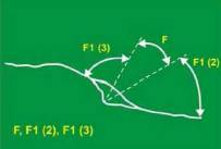
A ship steers the following courses and distances: 080° T for 42 miles, 201° T for 36 miles, 145° T for 27 miles, 045° T for 45 miles. Find the resulting distance and course made good.
150 miles approximately 100°.
140 miles approximately 110°.
160 miles approximately 90°.
155 miles approximately 95°.
What is the definition of the «luminous range» of a light?
Is the maximum distance at which a light can be seen at a given time.
Is the distance a light can be seen in clear weather only.
Is the distance a light can be seen during the day.
Is the distance a light can be seen at night.
Calculate the difference in latitude between the following two positions: 35° 20' N 20° 35' W and 50° 00' N 20° 35' W.
014°.
016°.
015°.
013°.
A vessel steamed 210 miles on a course of 180°. The departure point was 35°30' N. What latitude do you arrive at?
32°00' N.
33°00' N.
31°30' N.
34°00' N.
A ship steers the following courses and distances: 180° T for 22 miles, 290° T for 73 miles, 159° T for 68 miles, 270° T for 16 miles. What is the resulting direction and distance made good?
179 miles, approximately 240°.
180 miles, approximately 250°.
175 miles, approximately 230°.
182 miles, approximately 245°.
The technique used in radar pilotage for continuous monitoring of the vessel's position on the intended track is called ...
cross indexing.
presentation unstabilisation.
presentation stabilization.
parallel indexing.
From those listed, the best land target to use for a radar bearing is ....
a large headland.
a coastal indentation.
a sloping foreshore.
a small isolated feature.
In 45°34' N, a ship sails due east from 164°10' E to 170°20' E. Find the distance the vessel traveled?
370 mls.
362 mls.
366 mls.
360 mls.
When choosing objects for position fixing by radar ranges you should, if possible, avoid ....
large prominent features.
steep faced features.
small isolated features.
sloping land features.
When must a passage plan be prepared?
Gradually during a sea voyage.
Whenever requested by a pilot.
Any of the other options.
Before the voyage commences.
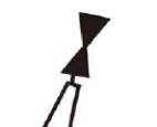
On which side of this buoy should you pass?
South cardinal buoy.
West cardinal buoy.
North cardinal buoy.
East cardinal buoy.
Find the true course to steer between initial position 16° 52' S 08° 51' W and 12° 46' S 11° 23' W.
approximately 90°.
approximately 280°.
approximately 180°.
approximately 360°.
A ship steers the following courses & distances: 135° for 30 miles 260° for 54 miles 169° for 42 miles 306° for 9 miles Find the resulting distance and course made good.
135 miles, approximately 210°.
150 miles, approximately 200°.
140 miles, approximately 220°.
130 miles, approximately 230°.
In which publication can information on ship reporting be found?
IAMSAR.
ALRS.
SOPEP manual.
Ship routeing.
The vertical distance between the sea bed and the deepest part of the keel is known as the ......
Draft.
Sounding.
Underkeel clearance.
Depth.
What is a routeing measure aimed at the separation of opposing streams of traffic by establishing traffic lanes called?
Recommended route.
Traffic separation scheme.
Separation zone.
Traffic lane.
How often are the NTMs (Notices to Mariners) published?
Weekly.
Monthly.
Bi-weekly.
Annually.
What is the vertical distance on a given day between the water surface at high and low water called?
Lowest astronomical tide.
Height of tide.
Highest astronomical tide.
Range of tides.
The best position fix is obtained when the bearings of two objects are ......
135° apart.
45° apart.
90° apart.
180° apart.
What are sailing directions also known as?
Pilot books.
Guide to port entry.
Routeing charts.
Passage planning charts.
Where is the title of the navigation chart printed?
Always at the bottom left hand margin.
Always at the center of the chart.
In some convenient, conspicuous place, where it does not hinder navigation or the use of it.
Where the sea areas are located.
Find the difference in longitude between initial position 50° 00' N 178° 00' W and 50° 00' N 179° 00' E.
002°.
001°.
003°.
004°.
When using great circle sailing the saving in distance is the most when ......
at the equator.
the course is N-S.
the course is E-W nearer to the poles.
the course is one of the inter-cardinal headings.
A light giving 4 flashes, which has sectors showing two different colours, could have an abbreviated description on the BA charts ....
Fl(4) .
Fl(2) .
Fl(3) .
Fl(5) .
Under soundings marked on the chart, the nature of the sea bottom is also indicated. What does Sh indicate?
Shingle.
Corals.
Shells.
Soft mud.
What charts are used for coastal and pilotage waters?
Instructional.
Small scale.
Large scale.
Routeing.
In which publication can information on VTS be found?
Routeing chart.
Tide tables.
ALRS.
Chart catalogues.
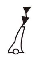
On a navigational chart, what does this figure indicate?
Direction lights.
Sector lights.
All of the other options.
Heading lights.
What is the line roughly following the 180th meridian called?
The equator.
The greenwich meridian.
A rhumb line.
The date line.
What is the meaning of the symbol Cl on a navigational chart?
Coral.
Cloud.
Cill.
Clay.
Where will you find a comprehensive list of navigation charts with their limits, titles, numbers and other information for various parts of the world?
Chart folio.
Chart 5011.
Sailing directions.
Chart catalogue.
In what direction does the axis of the gyro-compass motor normally point?
North relative.
Magnetic north.
Compass north.
True north.
How often is the BA chart catalogue published?
Weekly.
Monthly.
Twice a year.
Annually.
What charts are used for direct plotting Great Circle courses?
Routeing.
Instructional.
Gnomonic.
Passage planning.
Distance on a Mercator chart is measured using ......
Longitude scale.
Any uniform scale.
None of the given options.
Latitude scale.
What does this figure indicate on a navigation chart?
East cardinal buoy.
North cardinal buoy.
South cardinal buoy.
West cardinal buoy.
Find the true course to steer between initial position 50° 50' N 02° 00' W and 50° 00' N 01° 25' W.
approximately 095°.
approximately 100°.
approximately 090°.
approximately 085°.
What does this chart symbol mean?
Direction of tidal stream.
Direction of prevailing wind.
Direction of traffic lane.
Direction of buoyage.
Find the difference in longitude and direction between initial position 50° 00' N 02° 00' W and 50° 00' N 01° 25' W.
Difference 0°35', direction 90° E.
Difference 0°30', direction 85° E.
Difference 0°40', direction 95° E.
Difference 0°45', direction 80° E.
What is the definition of the «nominal» range of a light?
Is the luminous range when the meteorological visibility is 10 sea miles.
Is the maximum range under any conditions.
Is the range at which the light can be seen in perfect conditions.
Is the average range in normal weather conditions.
A ship steers 030° T for 120 miles. Find the difference of latitude and the departure.
Difference of latitude 002°.
Difference of latitude 003°.
Difference of latitude 001°.
Difference of latitude 004°.
The chart abbreviation «Al Fl WR 60 secs» indicates ...
Alternating Flash White flash followed by a red flash every 60 seconds.
Alternating Flash Red flash followed by a white flash every 60 seconds.
Continuous White light every 60 seconds.
Flashing White light every 60 seconds.
Find the true course to steer to the nearest degree between initial position 52° 00' N 04° 00' E and 52° 20' N 02° 26' E.
approximately 268°.
approximately 270°.
approximately 265°.
approximately 275°.
Charted depths are always measured below ....
All depths on a chart are measured below chart datum.
Mean sea level.
Lowest astronomical tide.
Highest astronomical tide.
Calculate the difference in latitude between the following two positions: 54° 35' N 02° 00' W and 50° 00' N 02° 00' W.
4°00' - 240 mls.
4°15' - 255 mls.
4°30' - 250 mls.
4°35' - 261 mls.
A vessel steamed 175 miles due east along the parallel of 48°25' N. If the longitude of the departure point was 8°19' W, find the final longitude.
5°25' W.
5°30' W.
5°20' W.
5°15' W.
From those listed, the best land target to use for radar ranging is a .....
a small rock.
a low-lying point.
an edge of land.
a cliff face.
Find the initial great circle course from 14°48' N, 78°18' W, to 37°54' N, 11°12' W.
approximately 45°.
approximately 50°.
approximately 40°.
approximately 55°.
A vessel changes latitude 244 miles to the north and makes a departure of 145 miles to the west. Find the course and made good.
approximately 330°.
approximately 320°.
approximately 340°.
approximately 310°.
Find the distance between initial position 50° 00' N 178° 00' W and 52° 00' N 179° 30' E.
approximately 120 mls.
approximately 130 mls.
approximately 110 mls.
approximately 140 mls.
A vessel is in 22° N and steams on a course of 000° T until it is in latitude 38° 14' N. What distance has she steamed?
800,0 mls.
968,4 mls.
1200,5 mls.
What is the true course to steer between initial position 49° 55' N 02° 50' W and 49° 05' N 01° 22' E?
85°.
approximately 100°.
120°.
On the chart, to find the course to steer to make good a course, allowing for current and leeway, the current and leeway would be applied ....
Compass error.
Drift adjustment.
Speed correction.
Heading adjustment.
The most appropriate chart for navigating when approaching a harbour is ....
Mercator chart.
Topographic chart.
Bathymetric chart.
Sailing chart.
Morning stars give a position 42°30' N, 24°25' W, and evening stars give a position 44°07' N, 20°07' W. Find the course and distance made good.
approximately 80°, approximately 250 mls.
approximately 90°, approximately 300 mls.
approximately 70°, approximately 200 mls.
approximately 75°, approximately 275 mls.
How is distance measured on a Mercator chart?
Nautical miles.
Miles.
Feet.
Kilometers.
From those listed, which would be the preferred method of position fixing for greatest accuracy and certainty of position?
2 or 3 visual bearing.
Single visual bearing.
GPS position.
Dead reckoning.
Calculate the difference in latitude between the following two positions: 05° 20' N 20° 35' W and 01° 25' S 20° 35' W.
03° 45' - 207 mls.
05° 30' - 150 mls.
02° 15' - 300 mls.
04° 00' - 250 mls.
Find the difference in longitude and direction between initial position 49° 55' N 02° 50' W and 49° 55' N 01° 22' E.
03° 30' - 200 mls - 45°.
04° 12' - 247,2 mls - 90°.
05° 00' - 300 mls - 60°.
02° 45' - 150 mls - 30°.
Did you find mistake? Highlight and press CTRL+Enter