In situations of peril, when every second counts, the ability to signal for help can be the difference between life and death. This is where the critical importance of Emergency Radio Beacons comes into sharp focus. These sophisticated devices, designed for use in maritime, aviation, and even land-based emergencies, serve as a lifeline, transmitting distress signals that alert search and rescue authorities to the location of those in need. This article will delve into the world of Emergency Radio Beacons, exploring the various types available, the technology behind their operation, the regulations governing their use, and the profound impact they have on search and rescue efforts worldwide.
Norway has been a pioneer country in the maritime sector and was among the very first to develop emergency beacons for Norwegian ships. This came largely as a result of several ship wrecks from which no distress signals were received.
Signals from beacons transmitting on the aeronautical frequencies 121,5 and 243 MHz, were originally only monitored by civilian and military aircraft.
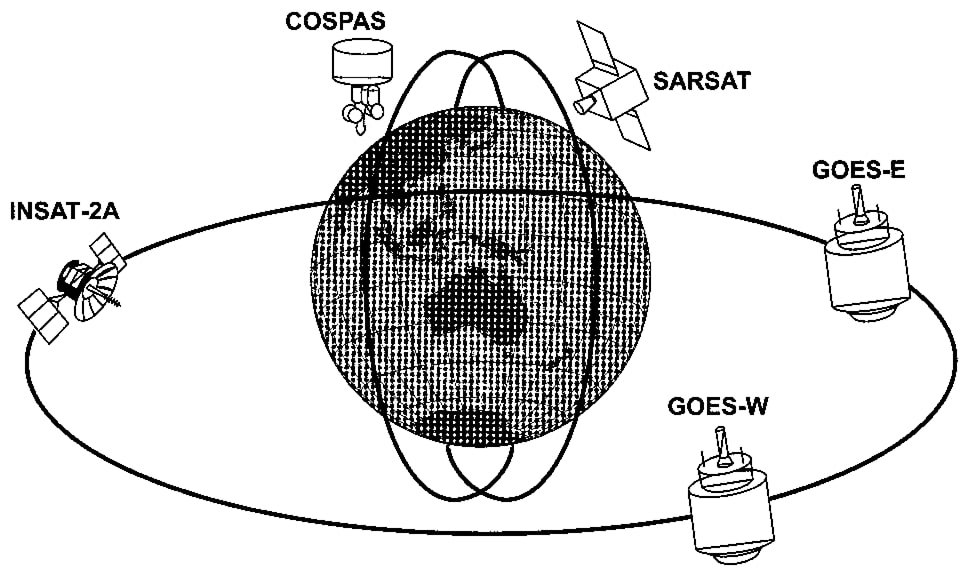
In 1980, the COSPAS/SARSAT agreement concerning a joint international satellite-aided search and rescue system was ratified by Canada, France, the United States and the USSR. Other countries have subsequently joined the programme, including the United Kingdom, Norway, Sweden, Finland, Brazil and Australia.
During the programmer’s first years of existence, ships were only fitted with VHF EPIRBs. But now a large amount of technically approved equipment is available, and both the aeronautical DSC (Digital Selective Calling) Procedures for VHF – MF and HFdistress frequency 121,5 MHz and the 406 MHz distress frequency are monitored.
IMO decided that from August 1, 1993, COSPAS/SARSAT or the Inmarsat-E float free EPIRB are mandatory on all ships covered by the SOLAS convention.
Different types of radio beacons
There are several types of emergency radio beacons in use today. These beacons are called EPIRBs, which stands for Emergency Position Indicating Radio Beacons.
The EPIRBs use different frequency bands, and can be grouped as follows:
- The 406 MHz COSPAS/SARSAT EPIRB, using polar orbiting satellites.
- The 1,6 GHz Inmarsat-E EPIRB (L-Band), using the Inmarsat geostationary satellites.
- The 121,5 MHz VHF EPIRB, monitored by polar orbiting satellites and aircraft.
- The VHF channel 70 EPIRB, using the DSC channel 70. (Not subject to mass production).
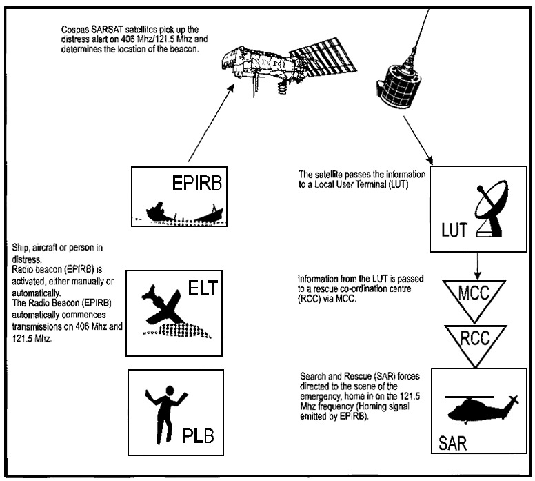
In distress situations, EPIRBs are activated either manually or automatically and start Transmission of Urgency and Safety Signals from a Vesseltransmitting signals which are received by satellites and aircraft. Signals picked up by satellites, are forwarded to earth stations for decoding and processing.
Basic Concepts of the COSPAS/SARSAT System
There are three main types of emergency radio beacons:
- ELT – Airborne;
- EPIRBs – Maritime, and;
- PLBs – Personal emergency radio beacons for use on land.
The COSPAS/SARSAT system was originally planned and developed for the use of low polar orbit satellites operating at an altitude of approximately 850 to 1 000 km. The system has been in operation since 1980 and up until the end of 1997 was involved in the rescue of 8 600 people during 2 600 SAR operations. Since 1996, the countries affiliated to Cospas/SARSAT have been experimenting with a new system that employs geo-stationary satellites in the detection of emergency alarms from Cospas/Sarsat EPIRBs.
The testing and evaluation of this new system was completed in 1998, and decisions were made to go in for further developments with a view to improving the ability to receive alarm signals within the COSPAS/SARSAT Inmarsat: A Guide to Satellite Communicationsatellite system.
The COSPAS/Sarsat-systems LEOSAR and GEOSAR are described below.
The LEOSAR system (Low Earth Orbit SAR satellite system)
The LEOSAR system is based on low polar orbit. The system is based on the use of the Doppler effect The Doppler effect: COSPAS/SARSAT – satellites are able to measure the variation in frequency that occurs as a result of the relative motion between satellite and emergency beacon.x which occurs between satellite and emergency radar beacon and which is used to determine the latter’s position.
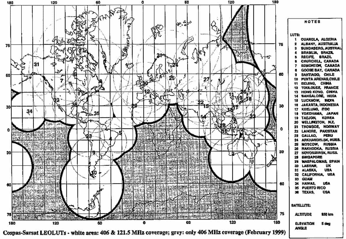
The carrier wave that is emitted is very stable (its frequency does not vary), and the position can therefore be calculated with an accuracy radius of approx. 2 kilometres. The system uses the aeronautical frequency 121,5 MHz and the 406 MHz frequency.
One of the advantages of using a 406 MHz emergency beacon is that it is possible to programme it to include the ship’s digital identification number (MMSI) in the message it sends to the satellite. In order to optimise the Doppler positioning capability, the satellites follow low polar orbits which result in short up-link times to the satellite, a clear Doppler shift, and short intervals between the passage of the satellites.
The 406 MHz emergency beacon is the only one with global coverage. The reason for this is that the received data transmission from the emergency beacon is stored in the satellite and relayed to LEOLUT (Local User Terminal in the LEOSAR system) when it achieves direct visibility to LEOLUT.
Read also: The Global Maritime Distress and Safety System – Principles & Practice
Emergency beacons that operate on the 121,5 MHz frequency do not achieve global coverage. The satellites function simply as “repeaters” and require unobstructed visibility to both the emergency beacon and LEOLUT in order to allow the position to be calculated. If a 121,5 MHz emergency beacon is activated in the southern Atlantic (South Africa), the satellite will be unable to provide LEOLUT with the information.
The 121,5 MHz frequency provides approximately 10 times poorer calculations of the emergency beacon’s position than the 406 MHz transmitter. Emergency beacons that transmit solely on the 121,5 MHz frequency are not approved for use in the GMDSS system.
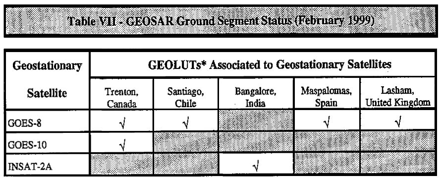
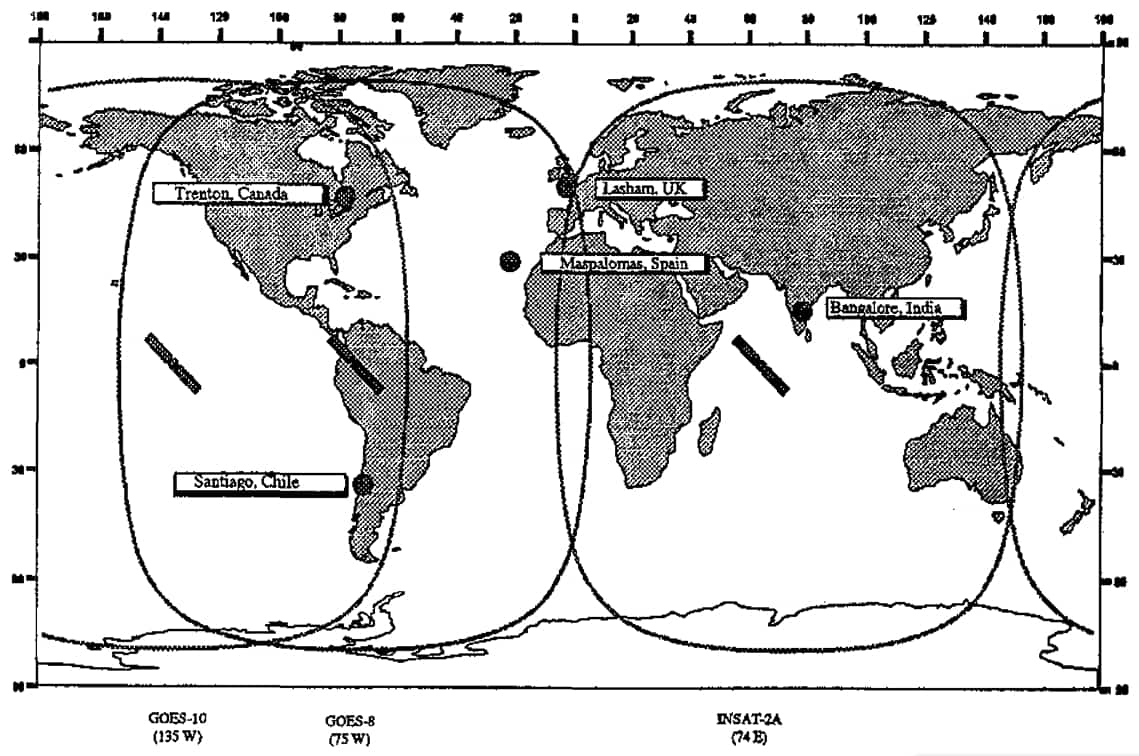
The GEOSAR system (Geostationary SAR satellite system)
The GEOSAR system employs geostationary satellites providing the possibility of close to real time alarms from a 406 MHz EPIRB. At present 406 MHz repeaters are installed in three geostationary satellites, and in one satellite which has the status of reserve. There is no Doppler effect on the up link frequency from EPIRB to geostationary satellite. This rules out the possibility of calculating the position with the help of the Doppler effect. In order to utilise the GEOSAR system in the best possible way, 406 MHz EPIRBs will be equipped with a built-in Use of Skywaves for Navigationnavigation receiver, GPS , that provides continuous updated positional data transmitted on the 406 MHz frequency in digital format.
It is also possible to connect the 406 MHz EPIRB to the ship’s on-board navigation equipment and as the EPIRB releases itself, the last updated position will be transmitted to the system, GEOSAR operative status also includes 6 COSPAS/SARSAT MCC network, that implement the distribution of GEOSAR alarms.
Facts about COSPAS/SARSAT as of December 1997
Emergency radio beacons world-wide:
- 406 MHz – 156 000 units;
- 406 MHz – approx. 200 000 units by the year 2000.
- LEOLUT – Operational: 36 in 1999;
- GEOSAR – Operational: 6 in 1999 (Trenton, Canada covers 2 geo-stationary satellites);
Space segment – COSPAS/SARSAT
- LEOSAR: 7 satellites in low polar orbit, orbit time 1 hour 40 minutes.
- GEOSAR: 3 satellites in geo-stationary orbit, plus 1 satellite in reserve.
Between 1982 and December 1997, the COSPAS/SARSAT system provided assistance in the rescue of 8 666 people during 2 636 SAR operations.
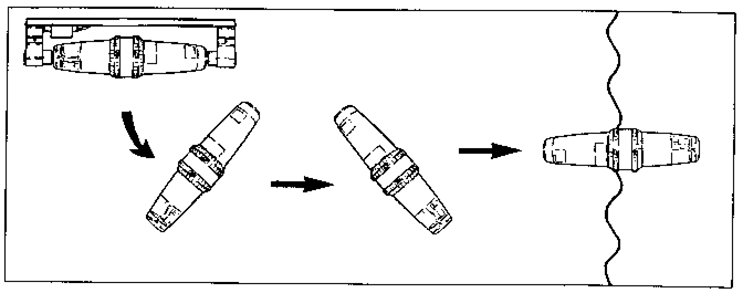
The COSPAS/SARSAT Beacon
In principle, the beacon consists of a digital logic unit, a transmitter, an antenna and a battery unit.
The signals transmitted are digital messages containing the ship’s identity and nationality.
As internationally agreed, the message from the beacon must be given as a certain number of figures. This number is known as the MARITIME MOBILE SERVICE IDENTITY, or the MMSI number.
The same number is also used for:
- DSC (Digital Selective Calling) on VHF/MF/HF including radio telex.
- Inmarsat B/C and M.
- Inmarsat-E EPIRB
You can find more information about MMSI numbers in item 7,5 of the DSC chapter of this book.
Transmission on 406 MHz:
The beacon transmits bursts of information every 50 seconds, with a duration of only 0,44 seconds. Radiated power is approximately 5 watts.
Transmission on 121,5 MHz:
The beacon transmits a continuous sweep-tone modulated signal, with radiated power of about 100 mW. Increased frequency stability and radiated power makes the 406 MHz EPIRB up to 10 times as accurate as the 121,5 MHz EPIRB.
Activation of the Beacon
The beacons can be activated in three different ways:
1 Manually.
- The seal must be broken, and die switch set to “TRANSMIT” or “ON”.
2 Automatically.
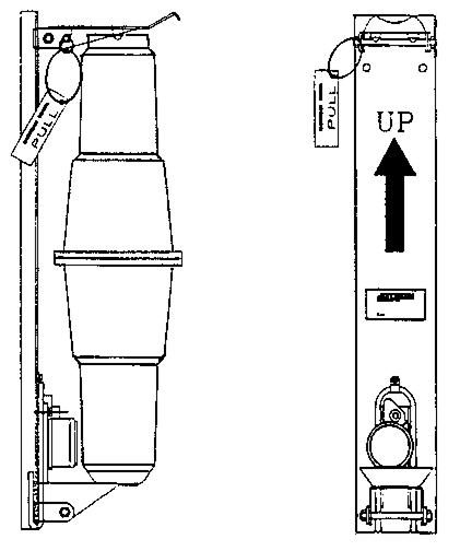
- When the release mechanism is submerged into water (2-4 meter), the beacon will float free, and start to transmit because of conduction between the seawater contacts.
3 Remote activation.
- Some beacons are fitted with a remote activation switch, which allows the beacon to start transmission even when the release mechanism has not been activated.
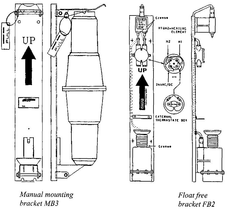
Float-free bracket FBH3 with built-in heating elements to avoid icing in polar areas.

Maintenance of the Beacon
The COSPAS/SARSAT system consists of several links. If the distress alert system is to operate in a Distress Signals And Distress Trafficdistress situation, all links must Sanction correctly. Therefore, the following general rules must be followed:
- Check that the EPIRB is placed correctly in the bracket.
- In the event of mechanical damage (cracks in the poly-carbonate material), replacement is required.
- if battery date has expired, replacement is required. (Do not try to change the battery yourself, as the unit must be kept totally waterproof).
- Check the marking of the beacon. The ship’s callsign and MMSI number must be permanently marked on the beacon.
- The beacon or the releasing mechanism must not be painted over. Also check the hydrostatic releaser if the releasing mechanism is fitted with one. Releaser life is usually 2 years.
And finally, read the instruction manual for your type of equipment.
VHF emergency beacons for manual activation
This type of beacon cannot be automatically released from a Transmission of Urgency and Safety Signals from a Vesselvessel in distress. It must be removed from the container where it is stored, and started manually. The frequencies in use are the aeronautical frequencies 121,5 MHz (civil aviation) and 243 MHz (military aviation). The beacon transmits a continuous sweeptone, with radiated power of approx. 0,2 watt. Operating time is 48 hours. This type of beacon uses Lithium type batteries which must be changed every 3-5 years.
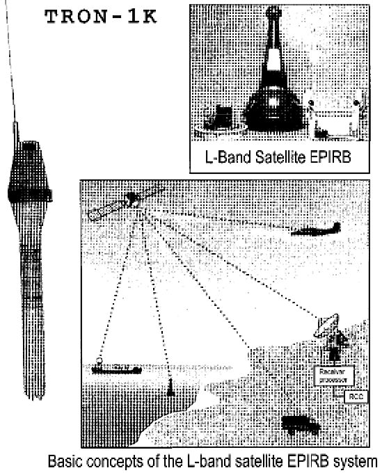
The Inmarsat-E EPIRB
This EPIRB uses the 1,6 GHz or L-Band for transmission of distress signals via Inmarsat geostationary satellites. The system was tested in 1982-83, and in 1987. The tests resulted in the decision to produce a “float free” satellite EPIRB for this band.
This type of EPIRB is equivalent to the COSPAS/SARSAT system beacons.
The basic features of the L-Band system are:
- float free satellite EPIRB;
- Inmarsat geostationary satellites;
- Inmarsat Coast Earth Stations with separate receiver and downlink equipment;
The system range is limited to sea area A3 and the Inmarsat-E EPIRB can be used by ships sailing in sea area A1, A2 and A3.
The EPIRB is able to transmit 20 equal alerts within a period of 10 minutes. On board a ship, it is possible to update the EPIRB with navigational data from GPS or other navigational receivers. The EPIRB can be activated both manually and automatically.
When activated, a GMDSS Distress and Safety Communicationsdistress message is transmitted in the following format:
- Ships ID (MMSI number);
- Latitude;
- Longitude;
- Last update of position;
- Nature of distress;
- Ships course;
- Ships speed;
- Activation time or last position update.
The transmission is repeated several times in a fixed cycle. When the signals are received by the satellite, they are relayed to the CES and decoded. Thereafter, the message is routed to the closest SSB or MRCC.
It will be interesting: Importance of Reliable Marine Communications and Empowering Maritime Industry
The figure on the previous page shows the basic features of the L-band EPIRB system. Within its coverage area, the EPIRB makes it possible to provide identity, position and additional information in approximate real time. At least one Coast Earth Station is always available for alerting.
See illustration above.
VHF Emergency Beacon (VHF beacon)
This EPIRB works on the maritime VHF band on channel 70 (156,525 MHz), and uses DSC signalling. It must be combined with a SART (Search and Rescue Transponder) for localizing purposes. The EPIRB is approved for sea area A1 instead of satellite EPIRB.
The EPIRB will transmit a standard DSC call with the following information/exceptions:
| Nature of distress: | EPIRB transmission |
| Position: | Need not to be included/the digit 9 is transmitted 10 times. |
| Time: | Need not to be included/the digit 8 is transmitted 4 times. |
| Subsequent communication: | No information indication/no subsequent communication will follow. |
| (Not subject to mass production) | |

- Global Maritime Distress and Safety System: IMO 1987.
- Manual for use by The Maritime Mobile and Maritime Mobile- Satellite Services: ITU 1992.
- Radio Regulations 1-2-3: ITU 1990.
- Manual for Norwegian Mobile Radiotelephone Stations: The Norwegian Telecom 1992.
- Modem Electronic Communication: Gary M. Miller 1978.
- Brochures and data sheets from manufacturers of GMDSS Equipment.
- Inmarsat: Inmarsat-A User’s Manual, Inmarsat-C User’s Manual.
- Nodposisjonering: Bjomar Augdal, 1992.
- Skipsantenner: Bjomar Augdal 1991.
- COSPAS-SARSAT Secretariat: COSPAS-SARSAT System Data Documents.
- Admiralty List of Radio Signals.