Delve into the fascinating history of Loran-C, a crucial navigation technology. This article covers its development, the impact of GPS, master/slave operations, synchronization with UTC, and the implications of Public Law 100-223.
- Abstract
- GPS: The First Impact on Loran-C
- Background of Loran-C Development and Time Synchronization
- General Developments
- Beginnings of Loran-C
- Master/Slave Operations
- UTC Control
- The Era of Public Law 100-223
- Loran-C Managerial Organization
- Synchronization to UTC Today
- Where Loran is Headed
- Disclaimer
- Questions and Answers
Learn about the managerial organization of Loran-C and explore its future trajectory in modern navigation systems.
Abstract
As of October 1, 1993, the US Coast Guard (USCG) supports and operates fifteen Loran-C chains. With the introduction of the Global Positioning System (GPS) and the termination of the Department of Defense (DOD) overseas need for Loran-C, the USCG wiU cease operating the three remaining overseas chains by December 31, 1994. Following this date, the USCG Loran-C system will consist of twelve chains.
Since 1971, management of time synchronization of the Loran-C system has been conducted under a Memorandum of Agreement between the US Naval Observatory (USNO) and the USCG. The requirement to maintain synchronization with Coordinated Universal Time (UTC) was initially specified as ± 25 microseconds (μs). This tolerance was rapidly lowered to ± 2,5 μs in 1974. To manage this synchronization requirement, the USCG incorporated administrative practices which kept the USNO appraised of aU aspects of the master timing path. This included procedures for responding to timing path failures, timing adjustments and time steps.
Conducting these aspects of time synchronization depended on message traflc between the various master stations and the USNO. To determine clock adjustment, the USCG relied upon the USNO’S Series 4 and 100 updates so that the characteristics ofthe master clock could be plotted and controls appropriately applied. In 1987, Public Law 100-223, under the Airport and Airway Improvement Act Amendment, reduced the synchronization tolerance to approximately 100 nanoseconds (ns) for chains sewing the National Airspace System (NAS). This action caused changes in the previous administrative procedures and techniques. This paper presents the actions taken by the USCG to meet the requirements of this law.
GPS: The First Impact on Loran-C
The DOD Global Positioning System (GPS) has significantly impacted the The Loran-C System: A More Detailed ViewLoran-C system, operated and supported by the USCG. The USCG originally operated Loran-C overseas based on a DOD need. When GPS was introduced, the DOD stated that their need for overseas Loran-C would terminate on December 31, 1994.
Following this date, the USCG will no longer have the authority to operate Loran-C overseas. Since the summer of 1992, the USCG has been reducing its overseas operation and support. On June 30, 1992, two of the three stations forming the Central Pacific Chain (GRI 4990) were turned off. The third station, Upolu Point, Hawaii, remained on air until December 31, 1992 to meet a continuing DOD timing need.
On October 1, 1993, four of the five stations in the western Pacific, and the control and monitoring functions which form the North West Pacific Chain (GRI 9970), were turned over to the Government of Japan. The Japanese have chosen to continue to operate this chain, minus the station located at Barrigada, Guam, to meet their own needs. In fact, Japan is actively taking steps to build a new master station and to modernize equipment within the chain.
With these modernization efforts, and considering other multinational developments between Japan, Russia, China and the Republic of Korea, Loran-C will continue to serve users in this part of the world into the foreseeable future.
The USCG is actively negotiating the future of ten Loran-C stations with seven countries in the European theater. Four of these chains are impacted by the overseas withdrawal of USCG operations and support.
The affected chains are:
- The Norwegian Sea Chain (GRI-7970);
- The Icelandic Sea Chain (GRI-9980);
- Mediterranean Sea Chain (GRI-7990),
- The Labrador Sea Chain (GRI-7930).
Three of the chains will be reconfigured almost immediately following December 31, 1994.
In the case of the Norwegian and Icelandic Sea Chains, all stations with the exception of Sandur, Iceland will be modernized and used as part of four new chains being developed under a multinational organization which formed the North West Europe Loran-C System (NELS). The current plan is to operate these four chains under a Time-of-Emission (TOE) control philosophy, with the master stations synchronized to UTC.
The current Labrador Sea Chain, a two-baseline chain formed by Fox Harbour, Canada , Cape Race, Newfoundland, and Angissoq Greenland, will be reconfigured following the closure of Angissoq. The Canadian Government has undertaken an initiative to build a new low powered master station at Comfort Cove, Newfoundland. The new chain, called the Newfoundland East Coast Chain, will have a GRI of 7270. This new chain will be supported by the USCG under a bilateral agreement with Canada.
With these turnovers, the Loran-C stations supported and operated by the USCG will be reduced to 29 stations comprising 12 chains. Five of these stations are in Canada. Three of the 12 chains will have Canadian master stations, and one of the twelve chains will have a Russian master station. These 12 chains, their GRIs, their master station location, and their Coordinator of Chain Operations (COCO) location are summarized in Table 1.
| Table 1. Post December 31, 1994 USCG Loran-C Chains | |||
|---|---|---|---|
| Chain | GRI | Master Location | COCO Location |
| NEUS | 9960 | Seneca, NY | Seneca, NY |
| GLKS | 8970 | Dana, IN | Seneca, NY |
| SEUS | 7980 | Malone, FL | Malone, FL |
| SOCUS | 9610 | Boise City, OK | Malone, FL |
| LABSEA | 7930 | Fox Harbour, NFLD | St. Anthony, NFLD |
| Canadian E. Coast | 5930 | Caribou, ME | St. Anthony, NFLD |
| Canadian W. Coast | 5990 | Williams Lake, BC | Middletown, CA |
| NOCUS | 8290 | Havre, MT | Middletown, CA |
| US West Coast | 9940 | Fallon, NV | Middletown, CA |
| Russian-American | 5980 | Petropavlovsk, CIS | Petropavlovsk, CIS |
| Gulf of Alaska | 7960 | Tok, AK | Kodiak, AK |
| NORPAC | 9990 | St. Paul, AK | Kodiak, AK |
Background of Loran-C Development and Time Synchronization
History. The possibility of developing a UHF hyperbolic, pulsed, radionavigation system capable of covering 300-500 miles for high-flying aircraft was first realized in the United States by Alfred L. Loomis of the Microwave Committee in October 1940. This committee was comprised of members from the Massachusetts Institute of Technology, government, and industry. This system, Loran-A, underwent consistent development and refinement. By the end of World War II, there were over 60 Loran-A stations transmitting.
Equipment Milestones
Some critical milestones included:
- Establishing 100-kW peak transmitters on two abandoned USCG lifeboat stations: Montauk Point, Long Island, New York and Fenwick Island, Delaware in 1942;
- Transition from 1,95 MHz to 170 and 180 kHz (LF Loran) in 1944;
- Development by Sperry Gyroscope in 1946 of Cycle-Matching Loran (CYCLAN) under contract with the Rome Air Development Center to produce a low-frequency system for navigation and guidance in precision bombing;
- Selection of the 90-110 kHz frequency band in 1951, and;
- Field-test resolution in 1954 of cycle ambiguity problems, which allowed system application to at least 1 000 miles.
Physical Milestones. The “atomic” clocks which would ultimately synchronize Loran-C operations were under development in June 1955 when the first time measurements using them were obtained at the National Physical Laboratory in Teddington, England. Between June 1955 and June 1958, statistical data were gathered which allowed defining the frequency of the hyperfine transitions of the ground state of Cesium-133 as 9 192 631 770 ± 20 cycles per second – the currently accepted value.
General Developments
The system called Loran-B was field tested in the Chesapeake Bay between 1959 and 1962. It tried to use the RF carrier to provide more accurate information than the previous envelope matching. It was intended for use in harbors and bays for mine laying operations. It was abandoned in 1962 due to several technical difficulties such as signal scattering from large ships and keeping the three stations synchronized.
The CYCLAN system was the next system to be developed, and it was able to resolve cycle ambiguity by using pulsed transmissions on two frequencies, 180 and 200 kHz. This system was later abandoned because there was international reluctance to grant a frequency clearance in the required band.
Beginnings of Loran-C
By 1957, the Navy had an operational requirement for a long-range, high-accuracy radionavigation system. This requirement gave rise first to the Cycle Matching Tactical Bombing and Navigation System (CYTAC) and then to Loran-C.
The first Loran-C chain was on the east coast of the United States and consisted of a master station at Carolina Beach, North Carolina and “slave” (now termed “secondary“) stations at Martha’s Vineyard, Massachusetts and Jupiter, Florida. It was originally operated by the Navy, but it was transferred to the USCG in 1958.
The instrumentation for high-speed recording of the time of arrival (TOA) of transient signals was developed by the National Bureau of Standards (NBS) in 1957-58. The development of the necessary techniques to use Loran-C for general purpose timing began in 1959 when NBS, USNO, and the Atlantic Missile Range (AMR) jointly developed the specifications for the first Loran-C Receiver Features and Their UseLoran-C timing receivers, and Sperry Gyroscope manufactured them.
Master/Slave Operations
In the original chain, timers used a servo system for controlling the cycle and envelope of both the master and slave stations. The master cycle servo used Automatic Frequency Control (AFC) circuits tied to the operate oscillator. The AFC attempted to keep each slave station’s oscillator synchronized to the master’s. To do this, the slave station tracked both the envelope and the cycle of the master signal at the 30-μs point. As the slave’s master-cycle servo tracked the master’s signal, it provided frequency correction to the oscillator. The main problem with this method was that noise in the master’s signal tended to be transmitted in the slave’s signal.
Although the USCG assumed responsibility for chain operations, the Navy was directed to supply the timing source, UTC, to Loran-C in 1960. Actual timing control between the master station at Carolina Beach, NC (also referred to as Cape Fear, NC) and the USNO began on May 22, 1961.
Around 1964, synchronization was changed to the so-called “free running” mode. The AFC circuits were removed, and the master cycle servo was locked down. The slave stations inserted Coding Delay Adjustments (now called Local Phase Adjustments or LPAs) by manually rotating the master cycle servo. Carolina Beach, NC, the master station for the east coast, had three rubidium oscillators and generated a 1-pulse-per-second (1 PPS) marker. The USNO monitored these 1 PPS signals for comparison to UTC and issued corrections as needed.
The steering of the east coast chain by USNO in 1964 was quite successful, and a decision was made in 1965 to provide a 1 PPS signal from all master stations. This feature was dropped in 1968 in favor of using the first pulse of the master’s phase code group A.
Initial precise steering by USNO was hampered because the three quartz oscillators at the transmitter were unstable. The NBS monitor at Boulder, Colorado revealed a diurnal frequency variation of 60 μs. This was soon traced to temperature changes in the transmitter room, to which the quartz was sensitive.
Practical steering within close limits was not achieved until late in 1961 when the quartz oscillators were replaced with the more stable rubidium units. The epoch for steering and time of coincidence (TOC) for the Loran-C chains had been previously defined to occur at OO hrs OO min OO secs on January 1, 1958.
UTC Control
The next technological advance affecting loran occurred in 1967 when the Cesium-133 second was adopted by the horology community. This was followed by a cooperative effort between the USNO and the USCG to purchase and install 35 Cesium beam standards in the loran stations. Two such standards were originally installed, and a third unit was added later. The USNO estimated that this would allow the epoch of Loran-C time to be traceable to their master clock to within ± 5 μs.
During the next six years, several major decisions were made which affected loran operations. In 1970 the Deputy Secretary of Defense informed the Secretary of Transportation that the Joint Chiefs of Staff agreed that the USCG should act as an agent of the USNO to provide precise time distribution for DOD via loran. In March 1971 the actual terms of agreement were signed, and the USCG then became the agent of the USNO to operate Loran-C for disseminating precise time and time interval.
An official USCG publication of 1975 states that the transmissions of six of the Loran-C chains were synchronized to within ± 25 μs tolerance of UTC. As early as 1972, however, it could be claimed that Loran-C was steered, in fact, to within ± 15 μs of UTC. This tolerance was gradually improved, first to ± 5 μs, and then to ± 2,5 μs by 1974. At that time, Loran-C was officially designated the primary navigation system for the Coastal Confluence Zone (CCZ) of the United States.
In early 1975 the loran rate structure was modified to add four new rates beyond the available forty-eight. This was necessary to accommodate the needs of the CCZ mandate.
Loran-C gradually expanded to offer greater coverage over the United States continental land mass. A survey of chain functionality shows the following availability:
- US West Coast (USWC) and Gulf of Alaska (GOA) – 1977;
- Northeast (NEUS) and Southeast (SEUS) United States – 1979;
- Great Lakes (GLKS) and Canadian West Coast (CWC) – 1980;
- Northern Pacific (NORPAC) – 1981;
- Canadian East Coast (CEC) – 1983.
Around 1977 the USNO began automating its Precise Time stations (PTS), and by 1981 the Precise Time Reference Stations (PTRS) were being used to monitor Loran-C timing. The PTRS stations could both collect timing data and steer loran stations remotely.
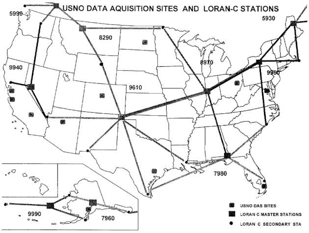
The present continental United States (CONUS) chain configuration was attained when the so-called “Mid-Continent Gap” was closed in 1991, At that time, the North Central (NOCUS) and South Central (SOCUS) chains became operational as the result of the Mid-Continent Expansion Project (MEP). Figure shows the current location of all the data acquisition sites and Loran-C stations within CONUS.
The Era of Public Law 100-223
The most recent action significantly affecting loran was the passage in 1987 of the Airport and Airway Improvement Amendments to the Airport and Airway Improvement Act (PL 100-223) of 1982. One major result of this law was that all master loran stations had to be synchronized to within approximately 100 ns of UTC by September 1989. The USCG and the USNO immediately collaborated to meet the requirements of this law, and a legal opinion was obtained which extended the deadline to a more manageable date.
As a first effort, the USCG and the USNO established the so-called “administrative” control methods in an attempt to determine the technical feasibility of this mandate. Four chains, NEUS, SEUS, GLKS, and USWC were subjected to periodic combinations of time steps and frequency adjustments, essentially between February and August 1989. The results indicated that these chains could only be held to within about ± 200 ns of UTC with 84 percent confidence.
A recent USCG report updated the synchronization work for loran operations between the passage of PL 100-223 and October 1993. In addition to the administrative methods, direct-view, common-view, and two-way time transfers via satellites had all been tested by June of 1993 at loran station (LORSTA) Seneca, NY, the master station of the NEUS chain. The results showed that two-way satellite time transfer could easily meet the requirements of the law. Unfortunately, it exceeded the USCG budget and had to be abandoned.
Read also: Introduction and Overview of Loran-C
Based on data gathered by the USCG, the USNO, and the National Institute of Standards and Technology (NIST), the most cost-effective means of achieving the 100 ns synchronization appeared to be Common-View Satellite Time Transfer (CVSTT). The data for this conclusion were gathered at LORSTA Seneca between January and June 1993 using CVSTT equipment which was calibrated, supplied, and installed by NIST. The initial results were highly favorable, as was anticipated based upon previous calculations estimating that this method would achieve the required synchronization to the four- or five-sigma level.
When fully operational, the CVTT control method will provide adequate Loran-C steering for all classes of users well toward the currently proposed 2015 date for loran operations.
Loran-C Managerial Organization
The COCO is the first-level manager of a Loran-C chain. Among the COCO’S many duties are the administrative actions of maintaining chain synchronization to UTC, as listed below.
A All Loran-C transmissions are synchronized to the UTC time scale, This scale is maintained by the USNO and is referenced to its master clock. All Loran-C chains are monitored by USNO, and data are published at periodic intervals via Time Service Announcements (Series 4 and Series 100).
B The responsibility to synchronize the Loran-C system to UTC rests with the USCG. Requirements and criteria are contained in a DOD and DOT Memorandum of Understanding. Specific responsibilities are:
- Program Manager: Maintain coordination with USNO for the purpose of updating, monitoring, and modifying requirements or procedures as necessary to ensure Loran-C transmissions are maintained within the specific UTC criteria.
- Regional Manager: Coordinate inter-chain and intra-chain synchronization for all Loran-C chains in each region.
- Chain Manager: Synchronize each chain to UTC and coordinate the overall intra-chain synchronization and frequency control of the master operate standard.
- Coordinator of Chain Operations: Perform intra-chain coordination and control all the frequency standards, excluding the master operate standard, unless the responsibility is otherwise delegated.
Synchronization to UTC Today
The CONUS far-field monitor sites operated by USNO for the purpose of monitoring the Loran-C stations in the United States and Canada are shown in Table 2, and the international monitor sites are shown in Table 3.
| Table 2. USNO UTC Monitoring Sites | ||
|---|---|---|
| Site/Location | Chain Monitored | Stations |
| Cape Canaveral, FL (1) | 7980 | All |
| Falcon AFB | ||
| Colorado Springs | 5990 | W |
| 9940 | M, Y | |
| 9610 | M, V | |
| 8290 | X | |
| Flagstaff, AZ | 9940 | M, Y |
| 9610 | M, V | |
| 8290 | M | |
| Newark AFB, OH | 8970 | M, X |
| (Will Close) | 9960 | M, Z |
| Elmindorf AFB, AK | 7960 | M, Y |
| 9990 | Z | |
| China Lake NAS, CA | 9940 | M, W, Y |
| 5990 | Y | |
| 9610 | M, W | |
| USCG Omsta Lamore, ND | 8290 | M, W, X |
| 9610 | M, V | |
| 8970 | M, Y | |
| Cape Canaveral, FL (2) | ||
| (No Control of Measurements) | 7980 | All |
| HP Santa Clara, CA | 5990 | Y |
| 9940 | W, Y | |
| 9610 | W | |
| USNO Washington, DC | 5930 | X |
| 7980 | Z | |
| 8970 | X | |
| 9960 | M | |
| USNO Miami, FL | 7980 | M, W, Z |
| 9960 | Y | |
| Vandenberg AFB, CA | 5990 | Y |
| 9940 | M, Y | |
| 9610 | W | |
This article does not attempt to explain the methodology of the USNO‘s derivation of individual chain offsets from UTC, but it is important for discussions which follow to mention that the entire process is built upon far-field monitoring. As one might expect, data collected from the far-field monitors have embedded signal path velocity changes which cannot be fully explained without some knowledge of what affects the timing equipment at the Loran-C stations. This is a question concerning the COCO, who is directly responsible for chain management.
Prior to Public Law 100-233, the USCG and the USNO used a rigid set of guidelines for managing Loran-C timing. The USCG used the USNO Series No. 4 and Series 100 time bulletins to compute time and frequency changes. With the exception of equipment malfunctions, all activity associated with chain frequency and time adjustments was preceded by a 14-day user notification.
Frequency changes, in the form of microstepper adjustments, were typically limited to magnitudes of less than 50 ns per day. Time steps, which are applied to all stations of a chain, are used to keep the chain within the prescribed tolerance of ± 2,5 μs of UTC. Time steps, rather than frequency adjustments, were often requested by the USNO so that users with special frequency needs could ignore frequency changes. Both frequency and time step changes were done world wide on Fridays at 1400Z. If a timing path failure occurred at a master station, corrective action was taken, and the USNO was immediately notified. The USNO used this information and annotated the change in the subsequent Series 4 bulletin.
| Table 3. USNO UTC Overseas/International Monitoring Sites | ||
|---|---|---|
| Site/Location | Chain Monitored | Stations |
| CRL Radio Telescope | 9970 | M |
| Tokyo Astronomical | 9970 | |
| Observatory | ||
| BIPM Paris, France | 7970 | M |
| Graz, Austria | 7990 | |
Typically, all frequency and time steps were based on at least than 30 days of data. The process was strict. It relied on recorded message traffic before actions were taken, and, as discussed in a previous section, it added numerous administrative layers to the USCG‘s management of Loran-C operations.
The 1987 amendments to the Airport and Airways Improvement Act of 1982 introduced several management changes within the USCG. First, this amendment required the USCG, working with the Federal Aviation Administration (FAA), to lower the synchronization of the Loran-C master stations serving the NAS to approximately 100 ns.
Second, it directed that a study would be made of the effect on users of using time-of-transmission (TOT) control versus control by the system area monitors (SAM).
Third, it required that a study would be made of the feasibility of synchronizing the time bases of the GPS and Loran-C systems to within 30 ns of each other. The purpose of this was to allow the exchange of navigation data between the two systems.
Where Loran is Headed
As this report shows, the USCG Loran-C system has consistently expanded since its inception to include more geographical coverage and to serve more users by adopting pertinent scientific and engineering advances.
Current plans call for this trend to continue. The next immediate step is to complete several months of steering the Seneca oscillator to either UTC (NIST) or UTC (USNO). This will definitely show whether control to UTC at the designated limits of PL 100-223 is feasible using CVSTT. The necessary equipment is already in place at LORSTA Seneca to complete data acquisition.
Based on the results of this steering, GPS receivers will be installed at all Loran-C master stations in CONUS, the GOA, and the CEC and CWC chains. This will meet the first stipulation of PL 100-223 , that all master stations be synchronized to within approximately 100 ns of UTC.
In addition, several other engineering advances are being planned to modernize the Loran-C system so that it can function in the NAS in cooperation with GPS. For instance, an Automatic Blink System (ABS) has recently passed most of its proof-of-performance tests at the USCG Electronics Engineering Center (EECEN). This system will automatically warn of a signal anomaly within 10 seconds that would prevent reliably using the loran signal for a non-precision approach.
The ABS will probably be installed at all loran stations sometime during calendar year 1995. It will also generate a 1 PPS signal which will help coordinate its time base with the GPS system time base and will thus fulfill the remaining stipulation of PL 100-223, that is, to coordinate the time references of loran and GPS to within 30 ns so that navigation data may be exchanged between the two systems and they can provide redundant navigational backups for each other.
Disclaimer
The opinions and positions expressed herein are solely those of the authors and do not necessarily represent the policies of the United States Coast Guard or any other government agency. The content provided is for information purposes only and may not be quoted or used for any other purpose.
Questions and Answers
J. Levine, NIST: Have you looked at the correlations between the station data and the remote monitoring data?
Lt. Norm Mason: We have not done that yet, mainly because we haven’t taken the data and refined it. Part of the problem is that we also want to look at the time of transmission and that has given us some problems. The data is not really valid enough to do a real hard look correlation.
Christine Hackman, NIST: You mentioned briefly that you had tried using two-way satellite time transfer. But you didn’t say much more than that, except for it worked. Could you just expand a little bit more on what you tried?
Charles Justice: Basically we had a two-way transfer antenna set up at Seneca, New York. We had personnel from USNO helping us to install this. Then they used their two-way satellite van up there to collect the data. And it was just about that simple. I think we were only there a day or two. And from the data that they got, as short as it was, it showed that we got excellent measurements; and they were 1 below 10 ns. I can’t remember exactly the level. If you are interested, we could send you the printouts of the charts that we got. But that was it. We had hoped to put these in at all of our master stations because we were pretty certain from those results, and also from two-way work at NIST and USNO being done for several years at least. I know it goes back at least a few years. We were pretty sure that it would more than meet the 100 ns requirement that the public law stated. But that is when we found out that our source of funds was going to dry up; we then had to drop the project because we couldn’t do anymore. We were originally going to set up the antennas at all the master stations and get the modems and everything else necessary. But that is as far as we could take it.

- Stenseth, Andreas, Status Report, “The North West European Loran-C System,” Norwegian Defence Communications and Data Services Administration, 1993
- Hefley, Gifford, “The Development of Loran-C Navigation and Timing,” U.S. Department of Commerce, National Bureau of Standards Monograph 129, October 1972.
- HIA Journal, Volume 10, May 1955.
- United States Coast Guard Academy, “Loran-C Engineering Course,” 1990.
- Gay, David R., Personal Communication, November 18, 1993.
- ODDR and Eltr to Superintendent, U.S. Naval Observatory, June 15, 1960.
- OB 09B62 from Superintendent, U.S. Naval Observatory to Commandant, U.S. Coast Guard (EEE), May 19, 1961.
- Hewlett Packard Application Note 57-2, “Timekeeping and Frequency Calibration,” 1986.
- Superintendent, U.S. Naval Observatory to Director Metrology, Headquarters Aerospace Guidance and Metrology Center, January 29, 1969.
- Letter from David Packard, Deputy Director of Defence, to the Honorable John A. Volpe, Secretary of Transportation, March 7, 1970.
- JCS 1411156-7, Note by the Secretaries to the Joint Chiefs of Staff, March 15, 1970.
- Terms of Agreement between the U.S. Coast Guard and the U.S. Naval Observatory, March 10, 1971.
- U. S. Coast Guard Manual 03-2224, “Aids to Navigation,” 1974.
- COMMANDANT NOTICE 3262, January 16, 1975.
- Potts, Cyrus E., and Wieder, Bernard, “Precise Time and Frequency Dissemination via the Loran-C System,” Proceedings of the IEEE, May 1972.
- Federal Radionavigation Plan, DOD-4650.4, DOT-TSC-RSPA-87-3, 1986.
- Federal Register Reprint 5-75, Volume 40, Number 29, February 11, 1975.
- COMDTPUB P16562.6, “Loran-C Users Handbook,” 1992.
- Wheeler, P.J., Time Service Department, U.S. Naval Observatory, Personal Communication, November 18, 1993.
- NAVOBSY – TSIPTTI SOP-81, “Precise Time and Time Interval Equipments,” 1981.
- H.R. 2310, “Airport and Airway Improvement Act Amendments,” October 6, 1987.
- Letter from Superintendent, U.S. Naval Observatory to Commandant, U.S. Coast Guard, August 2, 1989.
- U.S. Department of Transportation Working Group, “Report to Congress: Synchronization, Interoperation, and Minimum Standards for Radionavigation Systems,” August 1989.
- Westling, G.R., Sakahara, M.D., and Justice, C.J., “Synchronizing Loran-C Master Stations to Coordinated Universal Time,” Proceedings of the Eighteenth Annual Technical Symposium of the Wild Goose Association, October 1989.
- Justice, C.J., and Mason, LT A. Norman, “A Synopsis of Time Transfer Methods for Synchronizing Loran-C Master Stations to Coordinated Universal Time,” Proceedings of the Twenty-Second Annual Technical Symposium of the Wild Goose Association, October 1989.
- Allan, D.W., Time and Frequency Division, National Institute of Standards and Technology, Personal Communication, November, 1992.
- DOT-VNTSGRSPA-92-21DOD-4650.5, “Federal Radionavigation Plan,” 1992.