A key component of GMDSS is Maritime Safety Information (MSI), which provides mariners with crucial updates for safe navigation. This article will explore MSI GMDSS, explaining its purpose, the types of information it disseminates, and how it enhances safety at sea.
- The Navtex System
- Navareas
- Navarea I
- Building up a Navtex Message
- Examples of Navtex Messages
- National Navtex service
- The Navtex receiver
- EGC – Enhanced Group Call
- SafetyNET broadcast messages
- Availability of MSI in different NAVAREAS/METAREAS
- Reception of EGC messages – operating your EGC receiver
- EGC – message examples
- EXPLANATION OF THE EGC MESSAGES SHOWN ABOVE
- High frequency (HF) MSI
The Global Maritime Distress and Safety System makes specific requirements with regard to radio equipment, and ships must be able to carry out several different functions, one of which is the ability to TRANSMIT and RECEIVE Maritime Safety Information (MSI).
The Navtex System
Navtex (NAVigational TelEX) is an international telex system and is one of the most important elements of the GMDSS.
The system makes it possible for ships sailing in coastal waters to receive Maritime SafetyNET Service by Inmarsatsafety messages at distances of up to 400 nautical miles offshore, MS (messages can be transmitted by the NAVTEX system via the Inmarsat EGC system, or via short wave (HF) telex narrow band direct printing (NBDP).
The dedicated transmitting frequency of the NAVTEX system is 518 kHz. The system uses only one single frequency. To avoid mutual interference, both limited transmitter power and frequency time-sharing are required.
Careful coordination of broadcast schedules is imperative, and gives room for up to 24 stations in one NAVAREA. These 24 stations are divided into 4 groups consisting of 6 transmitting stations. Every group is allowed one hour of transmission time, and this means that every station can be “on the air” for 10 minutes every four hours. Areas with few stations will allow longer transmitting times.
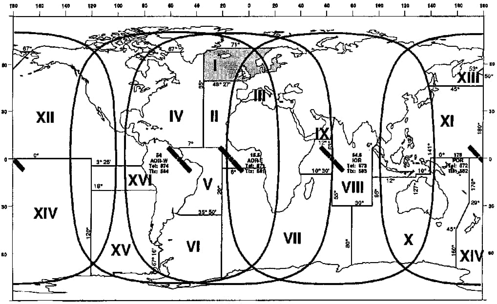
Navareas
The figure on the next page shows the different NAVAREAs worldwide. There are 16 of them altogether. The NAVTEX stations are geographically separated (A-Z), and the stations have their own “hours of duty”. Within the different Navareas, every Navtex station has its own identification character. This character is always a part of the preamble to the message.
Navarea I
The NAVTEX system started as early as 1980. The Barents Sea, the Norwegian Sea, the North Sea, the Baltic Sea, the English Channel and the Bay of Biscay are covered by NAVAREA I stations.
The table on page 122 shows all NAVTEX stations in NAVAREA I. Every station has its own characters for identification purposes. Which Navtex stations cover which particular areas is shown in the “List of Radio determination and Special Service Stations”.
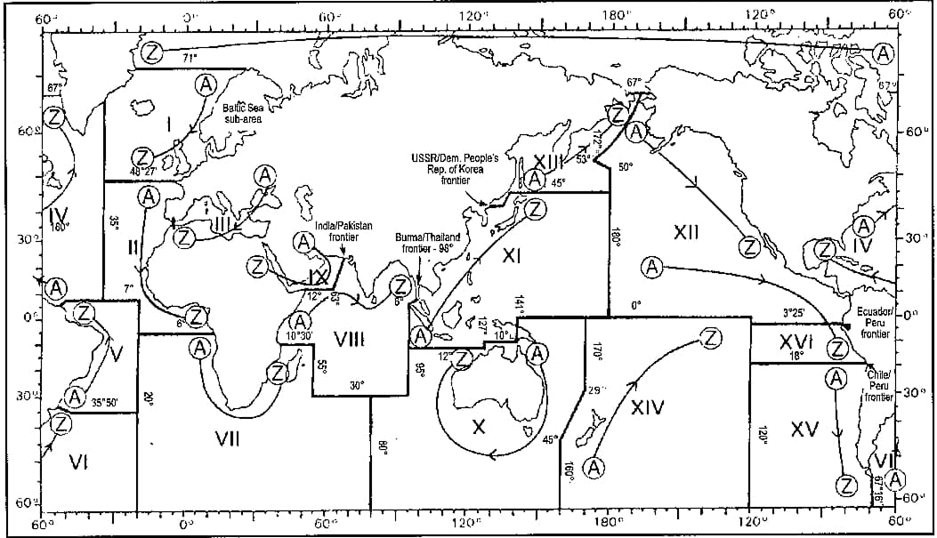

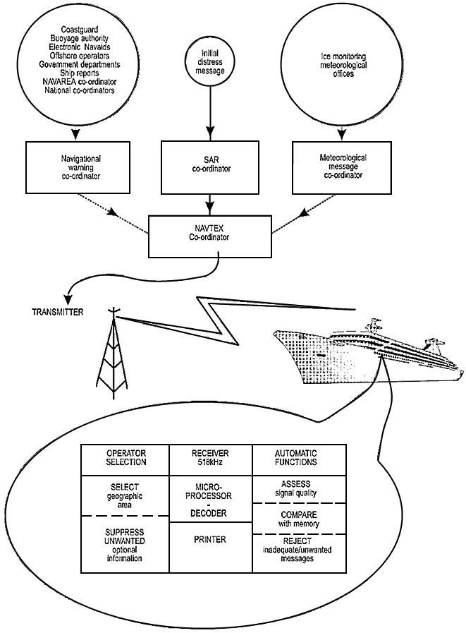
The NAVTEX coordinator in each NAVAREA decides which MSI messages the system is to broadcast.
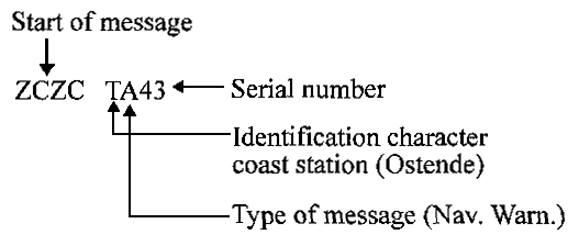
Building up a Navtex Message
We will now consider the preamble of a NAVTEX message. The dedicated Navtex receiver has the ability to select which messages are to be printed out according to:
- A four-character technical code (B1, B2, B3, B4) which appears in the preamble of each message.
- Whether or not the particular message has already been printed.
Certain essential classes of safety information, such as navigational warnings, meteorological warnings and SAR information are non-rejectable to ensure that ships using NAVTEX always receive the most important information.
Read also: Inmarsat: A Guide to Satellite Communication
The technical code B1 is a single character identification assigned uniquely to each station in a region (Navarea), allowing the navigator to select only broadcasting station(s) serving the region of interest.
The B2 character identifies the different classes of messages, as identified below, in order that the user may reject those which he does not require.
The subject indicators in use are:
- A – Navigational warnings (1).
- B – Meteorological warnings (1).
- C – Ice reports.
- D – Search and Rescue Information/Piracy information (1).
- E – Meteorological forecasts.
- F – Pilot service messages.
- G – DECCA messages.
- H – LORAN messages.
- I – OMEGA messages.
- J – SATNAV messages.
- K – Other electronic navaid messages (2).
- L – Navigational warnings for mobile drilling rig movements (1).
- V – Amplifying navigational warning information initially announced under “A”.
- Z – No messages on hand.
- Cannot be rejected by the receiver.
- Messages concerning radionavigation services.
The B3 and B4 characters of the technical code, number the messages from 01 to 99 in order of receipt by the sender, with the numbering maintained separately for each broadcast station B1 and subject class B2. The numbering starts over again using the numbers of expired messages after number 99 has been assigned.
Categories B3 and B4’s use of “00” (zero) acts to ensure that, regardless of broadcasting station (B1) or whatever has already been received by the station in correct form, the message will be printed out by all receivers within range of the transmitting station.
Type D messages (SAR-information) will always be numbered “00” (zero)
Examples of Navtex Messages
WZ 1262
ORKNEY ISLANDS
LOTHER ROCK RACON 58-44N 02-49W
TEMPORARILY OFF AIR
NNNN
In the example above, Cullercoats Radio has transmitted a navigational warning with serial number 20.
WZ 1253
RIGMOVE. SOUTHERN NORTH SEATCHARLES
ROWAN” AT 54-19N 02-07.7E
CANCEL THIS MESSAGE 121030 Z OCT 91
NNNN
The example above shows an additional navigational warning sent by Cullercoats Radio numbered 67.
NETHERLANDS COASTGUARD
GALE WARNING NR.55 280630Z OCT
DOVER THAMES – SOUTH 8
OTHER DISTRICTS – NO WARNINGS
NNNN
This example shows a gale warning from Scheveningen Radio numbered as 55.
National Navtex service
Earlier in this article we looked at the International NAVTEX service. The system uses the English language and is built up in the same way all over the world.
National transmissions, however, use the national language, but the preamble of the message has the same format as required by international agreement. Frequencies allocated are 490 kHz and 4 209,5 kHz.
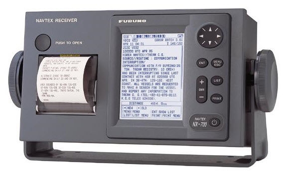
The Navtex receiver
Newer NAVTEX receivers are very compact, and are equipped with a built-in hard copy printer. As a result of modern technology, the ship is able to receive automated broadcast messages (MSI) on a 24 hour basis. The messages received are stored and printed out by the built-in printer. The micro processor prevents more than one printout per message. The Navtex receiver is of relatively small size, and therefore constitutes very useful additional equipment for smaller fishing vessels and yachts.
Technical specifications:
- International RX-freq.: 518 kHz;
- National RX-freq.: 490 kHz;
- Reception mode: FIB, Forward Error Correction;
- Range: 200 – 400 nautical miles.
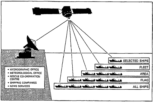
EGC – Enhanced Group Call
The EGC (Enhanced Group Call) services were developed by Inmarsat: A Guide to Satellite CommunicationInmarsat to achieve access to a unique global automatic service, capable of addressing traffic to predetermined groups of ships, or ships in both fixed and variable geographical areas.
The system gives ships access to different warnings, forecasts, shore-to-ship distress alerts, news and other necessary information. In addition to covering mid-ocean areas, the EGC system can offer automatic services in coastal waters where it may not be possible to establish the NAVTEX service.
A special feature of this system is the possibility of directing a call to a given geographical area. The area can be defined as a NAVAREA/METAREA, or may be uniquely defined. This feature of the EGC system is useful for such things as local storm warnings, or shore-to-ship alerts, regarding which it is inappropriate to alert all ships in an Ocean Region. Two EGC services are available:
The SafetyNET service allows an Information Provider, such as a meteorological or hydrographic office, to broadcast Maritime SafetyNET Service by InmarsatMaritime Safety Information (MSI) addressed to all, or selected, SES’s within an ocean region.
The FleetNET service is a commercial service and allows an Information Provider such as shipping companies or governments to broadcast information such as company news, or government information to selected SESs belonging to a closed network. To receive a FleetNET message, a SES must have downloaded the appropriate ENID code, and be synchronized to the appropriate NCS Common Channel. (ENID – EGC Network Identification).
SafetyNET broadcast messages
The following types of messages are broadcast via the EGC SafetyNET:
- Coastal warnings (Note 1);
- Navigational warnings;
- Meteorological warnings;
- Ice reports;
- Search and rescue information;
- Meteorological forecasts;
- Pilot service messages;
- Decca system messages;
- Loran system messages;
- Omega system messages;
- Satnav (GPS etc.) system messages;
- Other electronic navaid messages;
- Additional navigational warnings;
- Meteorological and NAVAREA warnings and meteorological forecasts to ships within specified NAVAREAs/METAREAs;
- Search-and-rescue co-ordination to fixed areas;
- Search-and-rescue co-ordination to ships within specified circular areas;
- Shore-to-ship distress alerts to ships within specified circular areas;
- Urgency messages and navigational warnings to ships within specified rectangular areas;
- Chart correction services (under development).
Notes:
1 The SafetyNET coastal warning broadcast facility is made available for transmissions of coastal information to areas where NAVTEX MSI is not provided
2 MSI messages are generally broadcast with a key-word in their header indicating the priority of the message – for example:
- DISTRESS or MAYDAY for priority 3,
- URGENT or PAN PAN for priority 2,
- SAFETY or SECURITE for priority 1.
3 In some areas SafetyNET MSI broadcast is limited, while information providers are being established, see following table. Corrected “List of Radio Signals” will show current situation.
Availability of MSI in different NAVAREAS/METAREAS
In order to avoid the duplication of broadcasts, IMO has authorized the following arrangements:
For a given NAVAREA/METAREA which is covered by more than one Empowering Global Communication with INMARSAT Satellites in shippingOcean Region satellite, scheduled broadcasts of MSI, such as meteorological warnings and meteorological information, are made only via a single satellite/Ocean Region.
For a given NAVAREA/METAREA which is covered by more than one Ocean Region satellite, unscheduled broadcasts of MSI, such as gale warnings and distress relay alerts, are made via all satellites/Ocean regions that cover the area in question.
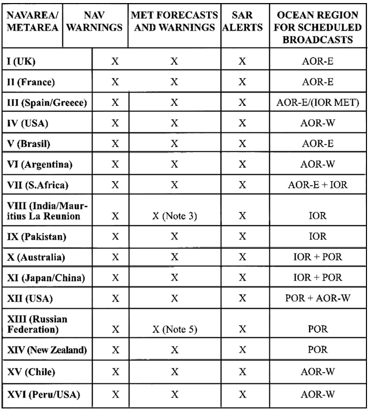
NOTES ON THE TABLE:
- X = Full service available
- IMO has decided that routine broadcasts of Navigational Warnings and Meteorological Forecasts will be made at scheduled times over a single nominated satellite for each NAVAREA/METAREA. Unscheduled broadcasts of SAR Alert Relays and severe weather warnings will be made over all satellites which serve the area in question. See the Inmarsat Maritime Communication Handbook (Issue 2) for further guidance.
- India provides meteorological forecasts and warnings in METAREA VIII north of equator through CES Arvi(IOR). Mauritius/La Reunion provides meteorological forecasts and warnings for METAREA VIII south of equator through CES Burum, Station 12(IOR).
- Full operational service expected in June 1998.
- South of 60 degrees north, full service is provided by Japan.
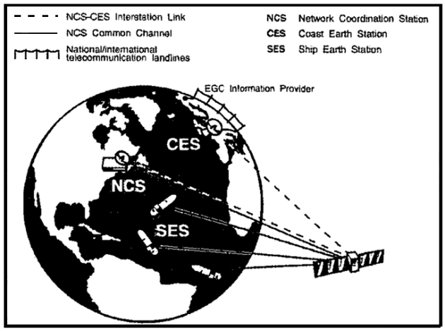
EGC broadcast to ships in NAVAREA I.
The figure also shows Navareas throughout the world.
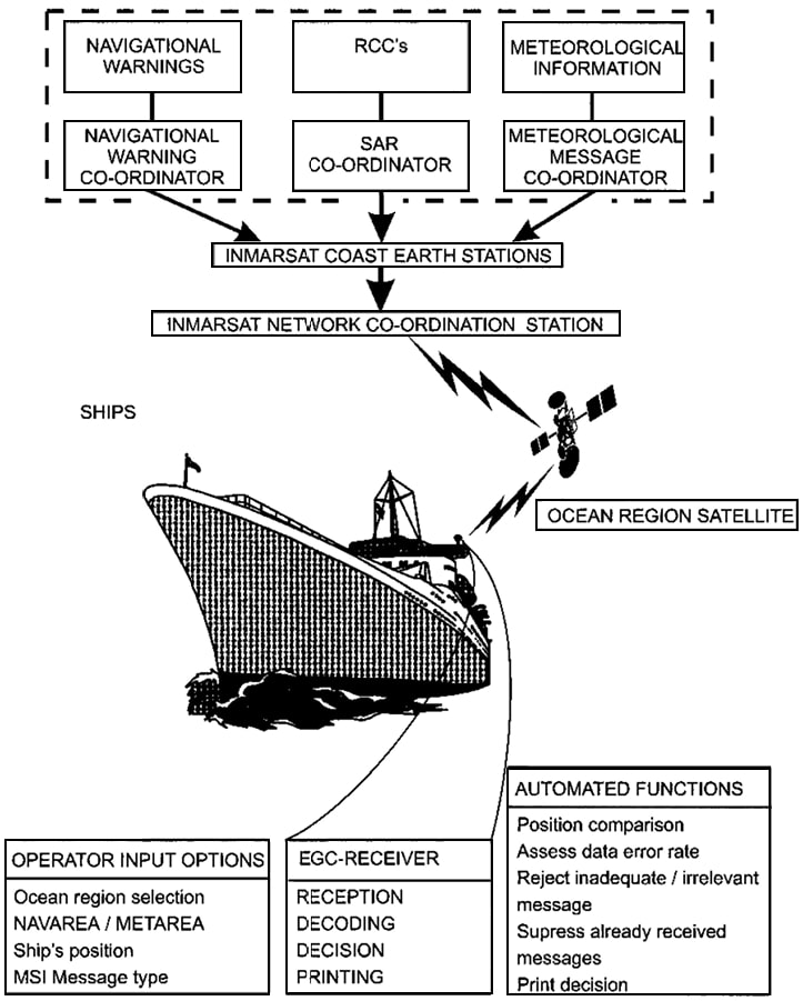
Reception of EGC messages – operating your EGC receiver
The EGC receiver is designed to continuously monitor the broadcast channel (the Inmarsat-C NCS common channel) and to process EGC SafetyNET messages transmitted over the satellite.
Note that certain classes of receiving equipment are not able to provide uninterrupted monitoring of the NCS Common Channel.
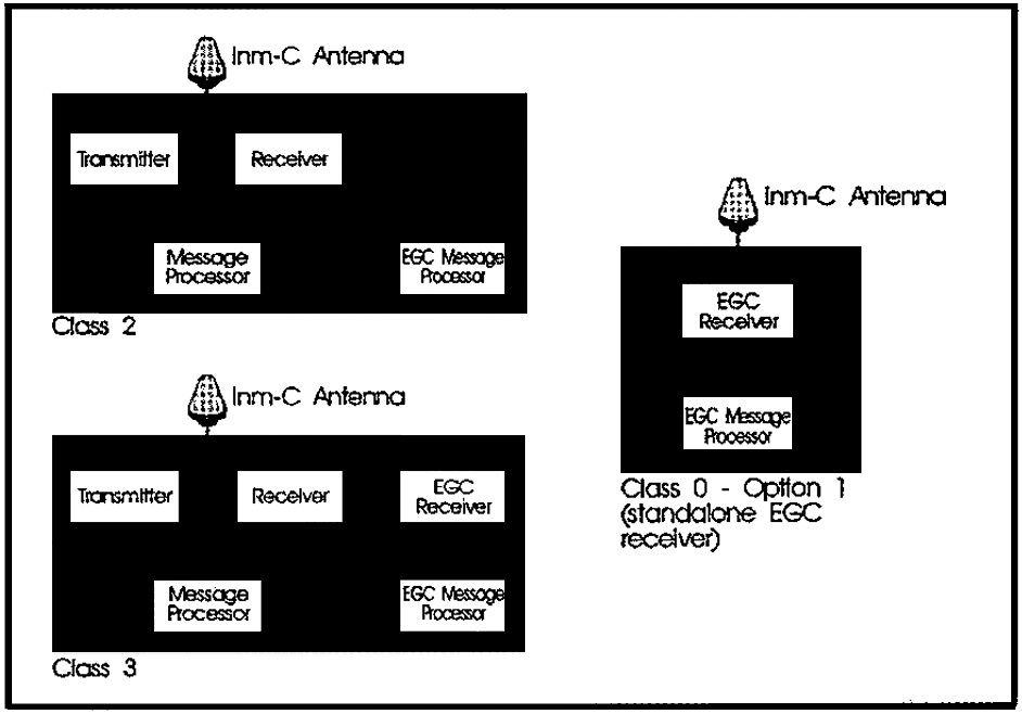
CLASS – 0 – OPTION 1: (standalone EGC receiver)
This type of SES can only receive EGC messages (there are no class 1 maritime terminals).
CLASS 2:
The SES can receive EGC messages when not engaged in normal (non EGC) message reception. When the SES receiver is engaged in normal message reception, it is tuned to the message channel assigned by the CES. As long as normal message reception is going on, the SES receiver is not tuned to the NCS Common Channel. Incoming EGC messages during this time will not be received.
Generally many EGC–SafetyNET messages will be repeated so it is possible to receive messages later if your EGC receiver is listening to the NCS Common Channel.
It will be interesting: Transmission of Urgency and Safety Signals from a Vessel
Normally unscheduled broadcasts such as distress alerts/gale warnings are re-broadcast 6 minutes after the initial transmission. Scheduled broad casts, like Informed for Safe Navigation at Sea with Critical Maritime Informationnavigational warnings and other messages valid for a period of time are repeated during the scheduled time as long as they remain in force.
CLASS 3:
The SES has two independent receivers, one capable of Inmarsat-C System Operation: From IMN to SCADAInmarsat-C message transfer at any time, and the other for EGC reception at any time. So operation of both modes without interruption is possible using this terminal configuration on board.
To obtain optimum results from the SafetyNET service, the operator must carefully read the manufacturers instructions for specific information about the following items:
Selective reception of messages
The receiver is supplied with software which stores the geographical boundaries of the NAVAREAS. The receiver uses this information to printout only messages applicable to the current area, plus any other areas which are programmed by the operator. The receiver can be programmed to print only essential messages and reject all other messages.
Updating the receiver regularly with ship’s position
Make sure that your EGC receiver is updated regularly with the ship’s position, in order to:
- Make sure that the receiver will print out all messages addressed to a geographical area.
- Print out messages for the required areas.
Note: If the EGC receiver has not been updated with the ships position for 12/24 hours (depending on model) the receiver will print/store all geographically addressed messages within the entire Ocean Region, the position can be updated in two ways:
- Automatically – using an electronic navigational device, e. g. a GPS (Global Positioning System).
- Manually – by typing the position directly into the terminal, IMO requires this to be done every 4 hours.
Mandatory EGC – SafetyNET messages
The following types of EGC – SafetyNET MSI messages are mandatory (SOLAS requirements):
- Shore-to-ship distress alerts for the current NAVAREAS;
- Navigational warnings for the current NAVAREA;
- Meteorological warnings for the current NAVAREA.
Note: Currently produced EGC receiver models are supplied with software which automatically selects the mandatory message types shown above. With some earlier models, however, the software does not select these mandatory message types automatically, consequently the operator must programme the EGC receiver manually.
Optional EGC – SafetyNET messages
In addition to the mandatory messages, IMO recommends that the EGC receiver also be programmed to receive the following messages:
- Meteorological forecasts.
- MSI for any other NAVAREAS in which the ship is expected to sail.
Reducing the number of alarms
The EGC receiver is programmed to give an audible/visual alarm on printing any GMDSS Distress and Safety Communicationsdistress alerts or urgent messages which require immediate response.
To avoid unnecessary alarms be sure to do the following:
- keep the ships position updated, to ensure that the receiver receives messages relevant to the ship’s position.
- set the receiver only to give alarms for messages with priority distress and urgency.
Maintaining good operating practice
- Make sure that all equipment associated with the EGC receiver is working properly. Check that the printer is loaded with paper/ribbon. Make sure that the terminal is not storing messages that are unwanted and that it has enough storage space for new messages.
- Make sure that the terminal is regularly updated with the ship’s current position
- Feed the terminal with NAVAREA/METAREA and coastal warnings relevant for the ship’s voyage.
- When staying in port, run the EGC receiver to make sure that it is functioning and to receive all relevant MSI messages before sailing.
- Scheduled MSI broadcasts are found in the current “List of Radio Signals”. Make sure that the EGC receiver is tuned to the appropriate NCS Channel you want to listen to at the scheduled time given in the “List of Radio Signals” (scan the desired Ocean Region).
- Keep a written log of the identities of all received messages, and printed copy of all distress traffic. Other messages should be kept on the bridge as long as they remain in force.
Missed messages
If, for example, you have missed a scheduled broadcast, try the following:
- Switch the terminal off and on again. This action will clear the internal memory of all stored messages, IDs. If the message is re-broadcast, your EGC receiver will not reject it as a repeated message, and will print/store it.
- Check if the CES that broadcast the message offers a re-broadcast facility, (This service is chargeable from some CESs).
EGC – message examples
NO.1
LES 1 – MSG – 28915 – Met/NavWam/Fore Safety Call to AREA: 4 – PosOK NAVAREAIV 582/95(27). OLD BAHAMA CHANNEL
185 FOOT FREIGHTER BEBO, GRAY HULL, WHITE
SUPERSRUCTURE WITH BRIDGE AFT, DISABLED AND
ADRIFT VICINITY 21-47N 82-21W. VESSEL REPORTS
FUEL PUMPS PROBLEMS AND IS REQUESTING TOW TO
THE BAHAMA BANK ANCHOR. VESSELS IN VICINITY
REQUESTED TO MAINTAIN SHARP LOOK OUT, ASSIST
IF POSSIBLE AND REPORT SIGHTINGS TO U. S COAST
GUARD.
NO.2
LES 322 MSG 25468 Nav/MetWam/Fore Safety Call to Area 10 – NoPos Y0701133/2
SECURITE
FM MRCC AUSTRALIA 010002Z JUL 97
NAVAREA X 011/97
HASTING ISLAND LIGHT K3446 POSITION 10 20.5S
151 52.0E REPORTED UNLIT
NNNN
NO.3
LES 121 MSG 2498 – MetWam/Fore Urgent Call to Area: 2 – PosOK
WARNING ON NAVAREA 2, ISSUED BY METEO-FRANCE,
TOULOUSE
WIND SPEED IN BEAUFORT SCALE
WARNING N004
WEST OF FARADAY
FROM 24 AUGUST AT 09 UTC TO 24 AUGUST AT 18 UTC
SOUTHWEST 8. =
EGC 926
NNNN
NO.4
(Heading of an EGC message)
Area: 47 N 28 W 200 PosOK
message………
EXPLANATION OF THE EGC MESSAGES SHOWN ABOVE
The above messages show a typical MSI broadcast as it is received on your terminal.
Note the following:
- The date and time of the messages in UTC time.
- Identification of the CES sending the message. UTC Inmarsat-C CES in EGC message 3.
- The unique number identifying the message, which is 2498 in EGC message 3.
- The priority of the message, in message 1, SAFETY, message 2, SAFETY and in message 3, URGENCY. When receiving DISTRESS/URGENT messages the terminal will respond automatically giving an audible/visual alarm.
- The nature of the message, message 3 is a Meteorological Warning for METAREA II.
- The term NoPos, this is a message giving information to the operator that the EGC receiver has NOT been updated with the ship’s position during the past 12/24 hours. The term PosOK indicates that the EGC receiver has been updated with ship’s position.
- In figure 4 there is a message heading which calls up ships within a circular area centred on 47 degrees North and 28 degrees West with a radius of 200 nautical miles. It is also possible to address messages to a rectangular area giving the co-ordinates of the southwest comer, and the easterly and northerly degrees. Note that in example number 4, the priority is DISTRESS.
High frequency (HF) MSI
The GMDSS also allows the reception of MSI via HF telex. Warnings for the different NAVAREAS are transmitted at fixed times and frequencies.
The “List of Radiodetermination and Special Service Stations” provides transmission times, DSC (Digital Selective Calling) Procedures for VHF – MF and HFfrequencies and coast stations for the different NAVAREAS. Students should also study the “List of Coast Stations”, Annex II, Part C, which gives particulars of coast stations transmitting MSI messages to ships by means of NBDP techniques.
| NAVTEX station list | |||||
|---|---|---|---|---|---|
| Nav-Area | Coast Station | Stn ID | Country | 1st TX of Day (UTC) | Interval (hrs) |
| I | Oostende | M | Belgium | 0200 | 4h |
| Oostende | T | Belgium | 0248 | 4h | |
| Tallin | U | Estonia | 0030 | 4h | |
| Reykjavik | R | Iceland | 0340 | 4h | |
| Valentia | V | Ireland | 0348 | 4h | |
| Netherlands C. G. | P | Netherlands | 0340 | 4h | |
| Svalbard | A | Norway | 0018 | 4h | |
| Bodo | B | Norway | 0018 | 4h | |
| Rogaland | L | Norway | 0018 | 4h | |
| Vardo | V | Norway | 0340 | 4h | |
| Murmansk | C | Russia | 0200 | 4h | |
| Arkhangelsk | F | Russia | 0200 | 4h | |
| Bjuröklubb | H | Sweden | 0004 | 4h | |
| Gislövshammar | J | Sweden | 0030 | 4h | |
| Ståvsnäs | U | Sweden | 0030 | 4h | |
| Cullercoast | G | U. K. | 0108 | 4h | |
| Niton | K | U. K. | 0140 | 4h | |
| Portpatrick | O | U. K. | 0308 | 4h | |
| Niton | S | U. K. | 0018 | 4h | |
| II | Cross Corsen | A | France | 0000 | 4h |
| Horta Radio | F | Portugal | 0050 | 4h | |
| Monsanto Radio | D | Portugal | 0250 | 4h | |
| Coruna | G | Spain | 0030 | 4h | |
| Tarifa | I | Spain | 0120 | 4h | |
| Las Palmas | I | Spain | 0120 | 4h | |
| III | Varna | J | Bulgaria | 0130 | 4h |
| Split | Q | Croatia | 0130 | 4h | |
| Troodos | M | Cyprus | 0020 | 4h | |
| Serapeum | X | Egypt | 0350 | 4h | |
| Cross La Carde | H | France | 0340 | 4h | |
| IV | Bermuda | B | Bermuda | 0010 | 4h |
| Sept Iles | C | Canada | 0020 | 4h | |
| Wiarton | D | Canada | 0110 | 4h | |
| St. Johns | O | Canada | 0220 | 4h | |
| Thunder Bay | Q | Canada | 0230 | 4h | |
| Sydney | Y | Canada | 0300 | 4h | |
| Yarmouth | J | Canada | 0325 | 4h | |
| Labrador | V | Canada | 0335 | 4h | |
| Miami | A | USA | 0045 | 4h | |
| Boston | F | USA | 0045 | 4h | |
| New Orleans | U | USA | 0300 | 4h | |
| Portsmouth | N | USA | 0130 | 4h | |
| San Juan | R | Puerto Rico | 0200 | 4h | |
| V | Colonia | Uruguay | Planned | ||
| Laguna del Sauce | Uruguay | Planned | |||
| La Paloma | Uruguay | Planned | |||
| Montevideo | Uruguay | Planned | |||
| Punta del Este | Uruguay | Planned | |||
| Salto | Uruguay | Planned | |||
| VI | Ushuaia | A | Argentina | 0240 | Under trial |
| Rio Gallegos | B | Argentina | 0410 | Under trial | |
| Com. Rivadavia | C | Argentina | 0400 | Under trial | |
| Bahia Blanca | D | Argentina | 0210 | Under trial | |
| Mar del Plata | E | Argentina | 0110 | Under trial | |
| Buenos Aires | F | Argentina | 0510 | 6h | |
| Rosario | G | Argentina | 0010 | Under trial | |
| VII | Walvis Bay | B | Namibia | Planned | |
| Cape Town | C | South Africa | 0020 | 4h | |
| Port Elizabeth | Q | South Africa | 0220 | 4h | |
| Durban | D | South Africa | 0120 | 4h | |
| VIII | Bombay | G | India | 0100 | 4h |
| Madras | H | India | 0230 | 4h | |
| Mauritius Radio | P | Mauritius | Planned | ||
| IX | Bahrain Radio | B | Bahrain | Planned | |
| Serapeum | X | Egypt | 0350 | ||
| Dammam | G | Saudi Arabia | 0605 | 6h | |
| Jeddah | H | Saudi Arabia | 0705 | 6-12h | |
| Muscat | N | Saudi Arabia | 0200 | ||
| X | NONE* | ||||
| XI | Sanya | M | China | 0200 | Planned |
| Guangzhou | N | China | 0210 | 4h | |
| Fuzhou | O | China | 0220 | Planned | |
| Shanghai | Q | China | 0240 | 4h | |
| Dalian | R | China | 0250 | 4h | |
| Jayapura | A | Indonesia | 0000 | 4h | |
| Ambon | B | Indonesia | 0020 | 4h | |
| Makassar | D | Indonesia | 0030 | 4h | |
| Jakarta | E | Indonesia | 0040 | 4h | |
| Otaru | J | Japan | 0130 | 4h | |
| Kushiro | K | Japan | 0140 | 4h | |
| Yokohama | I | Japan | 0120 | 4h | |
| Moji | H | Japan | 0110 | 4h | |
| Naha | G | Japan | 0100 | 4h | |
| Singapore | C | Singapore | 0050 | 4h | |
| Bangkok Radio | F | Thailand | 0050 | 4h | |
| Guam | V | USA | 0100 | 4h | |
| XIV | NONE | ||||
| XVI | Paita | S | Peru | 0300 | 4h |
| Callao | B | Peru | 0320 | 4h | |
| Mollendo | W | Peru | 0340 | 4h | |
| *Australia only provides coastal warnings through the International SafetyNet Service | |||||

- Global Maritime Distress and Safety System: IMO 1987.
- Manual for use by The Maritime Mobile and Maritime Mobile- Satellite Services: ITU 1992.
- Radio Regulations 1-2-3: ITU 1990.
- Manual for Norwegian Mobile Radiotelephone Stations: The Norwegian Telecom 1992.
- Modem Electronic Communication: Gary M. Miller 1978.
- Brochures and data sheets from manufacturers of GMDSS Equipment.
- Inmarsat: Inmarsat-A User’s Manual, Inmarsat-C User’s Manual.
- Nodposisjonering: Bjomar Augdal, 1992.
- Skipsantenner: Bjomar Augdal 1991.
- COSPAS-SARSAT Secretariat: COSPAS-SARSAT System Data Documents.
- Admiralty List of Radio Signals.