Effective maritime safety hinges on rapid and coordinated response. The pivotal role of the Maritime Rescue Coordination Center (MRCC) in this process cannot be overstated. These centers, strategically positioned globally, serve as the central hub for all distress alerts and rescue operations at sea.
From coordinating search and rescue (SAR) efforts to disseminating critical navigational warnings, the MRCC is vital for safeguarding life and property within its designated area of responsibility. This article examines the operational functions and technological advancements that enable the modern MRCC to maintain its crucial role in maritime emergency response.
The 1974 SOLAS Convention
The maritime distress and safety system which is defined in SOLAS (Safety of Lives at Sea) 1974 is based on the requirement that certain types of vessels at sea (depending on voyage undertaken) shall keep continuous listening watch on 500 kHz (morse), 2 182 kHz (RT) and on channel 16 VHF (RT).
The 3 above mentioned frequencies are dedicated international calling and distress channels. In accordance with SOLAS 1974, the minimum range of ship borne radio equipment is 150 nautical miles. Due to limited range, a Inmarsat-A: Equipment, Procedures, and Distress Communicationship in distress might only be assisted by ships in the vicinity of the incident.
This means that the SOLAS 1974 system only provides ship-to-ship operation in the case of a distress situation at sea. However, coast stations open for public correspondence are also required to keep continuous listening watch during service hours on the above.
The GMDSS System
Requirements made on Ship’s Antennas Systems and Radio Wave Propagationshipborne radio equipment within the GMDSS system depend upon which Sea Area the ship is operating in.
The Sea Areas are designated as follows:
A1 Coastal areas covered by VHF coast stations with the new DSC (Digital Selective Calling) signal System. Continuous alerting on VHF DSC is available.
A2 Sea areas covered by MF coast stations with DSC. Continuous alerting on MF DSC is available.
A3 Sea Areas covered by the INMARSAT geostationary satellite system. Continuous alerting within coverage of an INMARSAT geostationary satellite is available.
A3 All areas not included in A1, A2 or A3. Continuous alerting on HF DSC is available.
Continuous alerting is thus available in all of the defined Sea Areas.
The GMDSS takes advantage of modem automated technology in both satellite and Terrestrial Urgency and Safety Communications on the Vesselsterrestrial communication. One of the basic concepts involves ships being able to alert RCC’s (Rescue Co-ordination Centres) ashore, as well as ships in the immediate vicinity of the distressed ship.
When an alert is received by an RCC, it will be relayed to SAR units and to ships in the vicinity of the distress incident. In the GMDSS, arrangements have been made to provide three directional distress alerting: ship-to-shore, ship-to-ship and shore-to-ship. The results of this improvement include a high success rate for alerts, short alerting times and rapid response times thereby increasing the success of rescue operations at sea.
RCC’s – MRCC’s – SAR CO-ORDINATION
IMO has developed a SAR (Search and Rescue) Convention that requires countries to provide rescue services as well as a coast watching service along coastlines within their national jurisdiction. The purpose of the SAR Convention is to ensure that SAR services are available to mariners.
The basic idea of the convention is that all ocean areas should be divided into national Search and Rescue Regions (SRR). Furthermore, one or more MRCC’s should control/co-ordinate all maritime SAR activities within a certain SRR. The object is to achieve a global SAR system that fully complies with the GMDSS. However, only 38 countries have so far ratified the IMO SAR Convention, thus providing the SAR service that are specified therein.
Read also: The Essential Role of Power Supplies in Electrical Engineering on the Ship
Depending on whether a SAR incident occurs within or outside of a specified SRR, the SAR operation will be conducted in one of two ways: Inside SRR boundaries, a distress call is always routed to the responsible MRCC. The MRCC will co-operate with coast radio stations, coast earth stations and MCC’s (Cospas Sarsat Mission Control Centres). Assuming co-ordination of the SAR operation, the MRCC will make use of dedicated SAR units, ships and aircraft. An On-Scene Commander (from the SAR service) or a Surface Search Coordinator from a ship at the scene of the distress incident, will be designated to assist the MRCC in the SAR work.
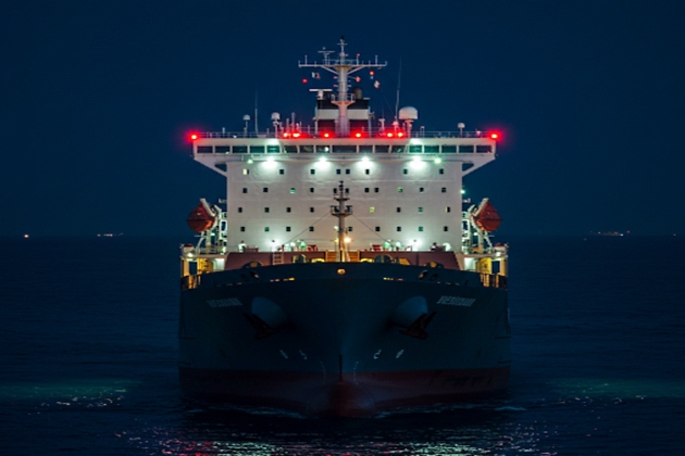
Source: AI generated image
Normally, a SAR operation carried out within SRR boundaries will be very efficient and function very well, since the shore-based rescue authorities (MRCC) have excellent knowledge of their own SRR and the resources available to them. Outside SRR boundaries, a distress call will be routed via coast radio stations, coast earth stations and MCC’s to an associated MRCC, which may be located thousands of miles away from the scene of distress.
When the MRCC has received the Distress Signals And Distress Trafficdistress call, its next step is to try and locate another MRCC or shore authority in the vicinity, or any ship (Surface Search Coordinator) that will take over responsibility and co-ordinate the assistance required. In effect we are back to the “old system” where sailor helped sailor without any support from shore-based rescue authorities.
When an MRCC receives a distress alert or information about dangerous situations at sea, it starts an immediate evaluation of the situation. MRCC’s use three different categories to define a distress situation at sea:
a The uncertainty phase.
b The alert phase.
c The distress phase.
In situations which reflect the first two phases, the MRCC will begin running communication checks, and at the same time make any inquiries it can in order to provide the best possible background information about the ship. Further action taken by the MRCC will be based on all the information at hand, and at this point, the MRCC will also alert the appropriate SAR resources to prepare them for action.
When the distress phase occurs, the MRCC has no time to lose. The MRCC will start working as soon as possible, and its first task will be to determine the position of distressed vessel as accurately as possible.
Information on the position of the distressed vessel is very important in enabling the MRCC to calculate the extent of an area to be searched in by SAR units. At this stage the MRCC will request assistance from services not generally included in the SAR organization, such as aircraft, vessels or other services. The relaying of a distress alert from an MRCC to the vessels in the vicinity of a distress incident, will be carried out via satellite communication to SES’s (Ship Earth Stations) and by Terrestrial Urgency and Safety Communications on the Vesselsterrestrial communication systems on dedicated frequencies.
To avoid alerting all ships in a large sea area, a distress call will be addressed to a specific ship, a selected group of ships or to ships within a specified geographical area.
Other important tasks undertaken by MRCC’s include:
- Informing the owner/agent of the vessel about the situation;
- notifying other RCC/Rescue Sub-Centres;
- informing consular/diplomatic authorities;
- notifying aircraft, vessels and other SAR services when assistance is no longer required.
In conclusion, there is still a lack of agreement outside SRR boundaries and many countries have yet to ratify the SAR Convention. Most of the countries involved, however, are endeavouring to work within the guidelines recommended by IMO.
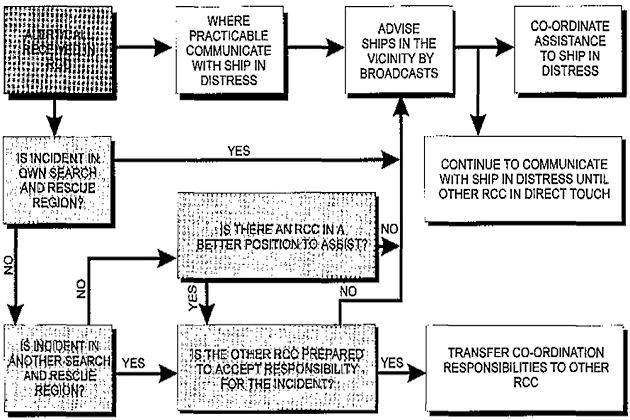
As a special service, IMO has developed guidelines for use by MRCC’s, containing procedure for handling distress alerts that originate outside SRR boundaries. This service includes a SAR flow-chart showing communications and procedures.
Action by the First RCC on Receipt of Distress Alert
A Genuine Rescue Operation
The following example of a real event illustrates the co-ordination work of an MRCC when receiving a distress call from a ship outside its SRR boundaries. Towards the end of 1994, the value of the GMDSS as a saver of lives was proven when the cruise vessel “Achille Lauro” had caught fire in position around the Horn of Africa en route to the Seychelles. About 1 000 people were saved thanks to co-operation between MRCC’s and the use of Inmarsat: A Guide to Satellite Communicationcommunication systems within the GMDSS.
MRCC – South Norway located in Stavanger received an INMARSAT–A call from the Dutch livestock carrier “Corriedale Express” Corriedale Express had received a message on 500 Khz (morse), from another vessel with callsign “HSDL”, that “Achille Lauro” was on fire and needed immediate assistance. The first action taken by MRCC Stavanger was to notify all vessels in the area of the incident by way of an EGC SafetyNet broadcast using all Inmarsat systems. Falmouth MRCC UK was rebroadcasting all Inmarsat–A messages using the Inmarsat–C system.
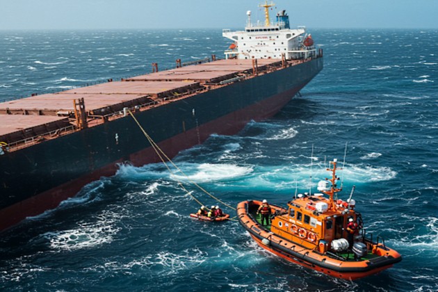
Source: AI generated image
In this way, MRCC Falmouth UK assisted MRCC Stavanger so that the ships on the scene were fully informed about the distress situation. Several vessels in the area responded immediately. MRCC Stavanger appointed the Shell tanker “Lima” as Surface Search Coordinator, as this ship had the best “all round” communication system in the area of the incident. Due to the absence of MRCC facilities on the east coast of Africa, MRCC Stavanger assumed responsibility for operations and began coordinating the SAR operation. MRCC Stavanger plotted the positions, course and speed of the vessels in the area (the rescue fleet).
The first ship to arrive on the scene, the tanker “Hawaiian King”, proceeded to establish VHF communication with “Achille Lauro”. She reported that most of the passengers and crew from “Achille Lauro” had abandoned ship and boarded the lifeboats and life rafts. The evacuees were in no imminent danger as several ships were steaming for the “Achille Lauro’s” position. The weather in the area was characterised by a calm wind and a rather low cloud base which reduced visibility to approximately 1 to 2 nautical miles.
It will be interesting: Exploring the Future of Satellites
MRCC Stavanger did not want to risk a collision in the distress area due to the abundance of vessels there, so all but eight were asked to stand down. The “Hawaiian King” rescued most of the people from the boats and the bulk carrier “Bardu” rescued the rest of the evacuees from the stricken ship. As far as communication is concerned, MRCC Stavanger kept in contact with the rescue fleet with the help of the INMARSAT–A and Inmarsat-C systems.
However, the quality and accessibility of the communication link with the ships involved caused an unexpected problem.
MRCC Stavanger lost contact with the rescue ships for about 2 hours because calls from the media and other authorities occupied INMARSAT lines. To solve this problem, a dedicated telex link was set up with the “Lima” and the “Hawaiian King” via Eik CES, Norway. Nearly 1 000 people were evacuated from the “Achille Lauro” and only 2 lives were lost.
As far as MRCC Stavanger is concerned, their main task in this SAR operation was one of co-ordination work, which extended beyond the rescue work. MRCC Stavanger dealt with all the parties involved, including shipowners, insurers, the authorities in the survivor’s home countries and the US Navy.
The incident also proved that relayable communication links such as those offered by the GMDSS, have greatly increased the ability shore-based rescue authorities to alert other ships at sea. Finally, two American warships were dispatched by the US Navy to steam down to the distress position and pick up survivors, provide water, food and shelter, and bring the survivors to safety.
All of this was done via the INMARSAT communication system!
RCC/MRCC in the Nordic Countries
DENMARK:
Denmark’s search and Rescue Co-ordination Centre is MRCC Aarhus. Radiocommunication with ships in distress is carried out via three MRSC’s under the control of MRCC Aarhus.
Danish coast radio stations maintain continuous listening watch on the international distress frequencies.
| MRCC ARHUS | |
|---|---|
| TELEPHONE | 45 89433099 |
| FACSIMILE | 45 89433230 |
| TELEX | 55 64485 RCCARH DK |
NORWAY:
The Norwegian Police Force is responsible for co-ordinating SAR activities from two main RCC’s in Stavanger and Bodoe. Norwegian coast radio stations maintain a continuous listening watch on the international distress frequencies.
| MRCC STAVANGER | |
|---|---|
| TELEPHONE | 47 51517000 |
| FACSIMILE | 47 51652334 |
| TELEX | 56 33063 RCCS N |
| MRCC BODOE | |
|---|---|
| TELEPHONE | 47 75521267 |
| FACSIMILE | 47 75524200 |
| TELEX | 56 64293 |
FINLAND:
The Frontier Guard is responsible for co-ordinating SAR operations in Finland. SAR activities in Finland are divided into three areas, the Gulf of Finland, the Archipelago Sea Coast and the Gulf of Bothnia CG Districts.
Finnish coast radio stations maintain a continuous listening watch on the international distress frequencies.
| MRSC HELSINKI | |
|---|---|
| TELEPHONE | 90667766 |
| TELEX | 57124777 SLMJK FIN |
| MRCC TURKU | |
|---|---|
| TELEPHONE | 9212333777 |
| TELEX | 5762249 SMMV FIN |
| MRSC VAASA | |
|---|---|
| TELEPHONE | 9613174859 |
| TELEX | 57 74225 PLMV FIN |
SWEDEN:
SAR activities in Sweden are co-ordinated through two MRCC’s located in Stockholm and Gothenburg and one MRSC located in Gotland. The MRCC’s and MRSC can be contacted directly or via Swedish coast radio stations.
Vessels are requested to forward any alerts as soon as possible to the respective MRCC via any coast radio station.
| RCC STOCKHOLM | |
|---|---|
| TELEPHONE | 46 8-6017901 |
| FACSIMILE | 46 8-6017969 |
| TELEX | 54 13335 |
| MRCC GOTHENBURG | |
|---|---|
| TELEPHONE | 46 31 -648020 |
| FACSIMILE | 6 31-247946 |
| TELEX | 4 20180 MRCCGBGS |

- Global Maritime Distress and Safety System: IMO 1987.
- Manual for use by The Maritime Mobile and Maritime Mobile- Satellite Services: ITU 1992.
- Radio Regulations 1-2-3: ITU 1990.
- Manual for Norwegian Mobile Radiotelephone Stations: The Norwegian Telecom 1992.
- Modem Electronic Communication: Gary M. Miller 1978.
- Brochures and data sheets from manufacturers of GMDSS Equipment.
- Inmarsat: Inmarsat-A User’s Manual, Inmarsat-C User’s Manual.
- Nodposisjonering: Bjomar Augdal, 1992.
- Skipsantenner: Bjomar Augdal 1991.
- COSPAS-SARSAT Secretariat: COSPAS-SARSAT System Data Documents.
- Admiralty List of Radio Signals.